Approximate Location Map
Large Map »
Latitude: 51.6444 / 51°38'39"N
Longitude: -1.8546 / 1°51'16"W
OS Eastings: 410158
OS Northings: 193961
OS Grid: SU101939
Mapcode National: GBR 3RV.ZXV
Mapcode Global: VHB2Z.SXXT
Plus Code: 9C3WJ4VW+P5
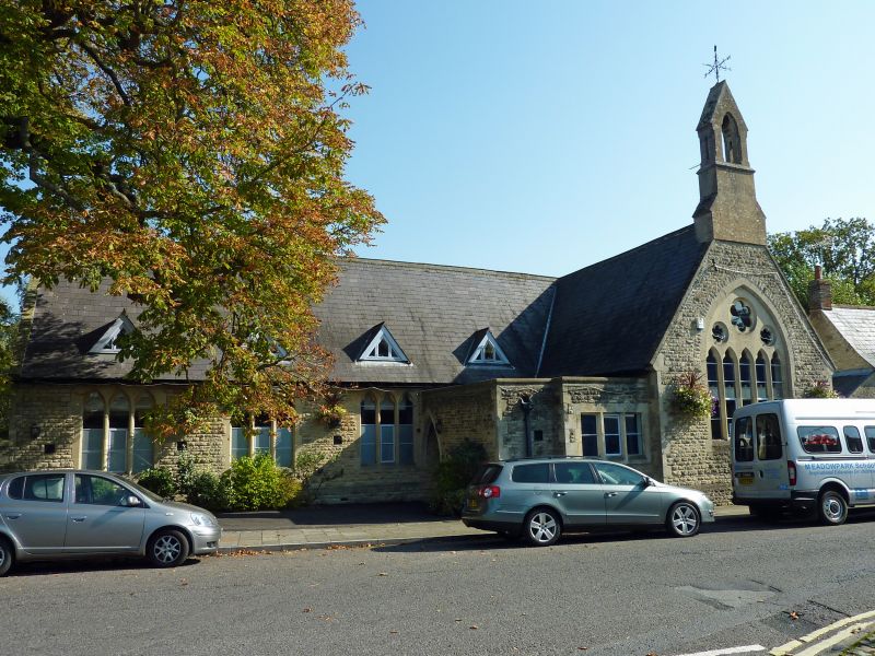
Entry Name: Old School
Listing Date: 17 April 1986
Grade: II
Source: Historic England
Source ID: 1183206
English Heritage Legacy ID: 317810
ID on this website: 101183206
Location: Cricklade, Wiltshire, SN6
County: Wiltshire
Civil Parish: Cricklade
Built-Up Area: Cricklade
Traditional County: Wiltshire
Lieutenancy Area (Ceremonial County): Wiltshire
Church of England Parish: Cricklade
Church of England Diocese: Bristol
Tagged with: School building
SU 19 SW CRICKLADE HIGH STREET
(east side)
13/160 Old School
GV II
Primary school. Circa 1870-80. Rock faced limestone with Welsh
slate roof. L-plan with gable to street capped with tall bellcote.
Five-light plate tracery window with hexfoil openings at head.
Paired gables to south with large square windows with timber
mullions. Entrance in flat roofed extension in re-entrant angle.
Metal roof ventilators. Windows to west and east trefoil headed 3-
light. Listed for group value, the building is a dominant element
in the street scene providing a good stop to the east side of the
street.
Listing NGR: SU1016093967
External links are from the relevant listing authority and, where applicable, Wikidata. Wikidata IDs may be related buildings as well as this specific building. If you want to add or update a link, you will need to do so by editing the Wikidata entry.


Other nearby listed buildings
