Latitude: 53.7488 / 53°44'55"N
Longitude: -1.4735 / 1°28'24"W
OS Eastings: 434820
OS Northings: 428176
OS Grid: SE348281
Mapcode National: GBR LT42.SW
Mapcode Global: WHDBY.B1LF
Plus Code: 9C5WPGXG+GJ
Entry Name: Long Acre
Listing Date: 26 September 1979
Grade: II
Source: Historic England
Source ID: 1184716
English Heritage Legacy ID: 342113
ID on this website: 101184716
Location: Rothwell, Leeds, West Yorkshire, LS26
County: Leeds
Electoral Ward/Division: Rothwell
Parish: Non Civil Parish
Built-Up Area: Rothwell
Traditional County: Yorkshire
Lieutenancy Area (Ceremonial County): West Yorkshire
Church of England Parish: Rothwell Holy Trinity
Church of England Diocese: Leeds
Tagged with: Building
SE 32 NW
5/99
26th September 1979
ROTHWELL LS26
OULTON LANE
(south side), Rothwell
Long Acre
GV
II
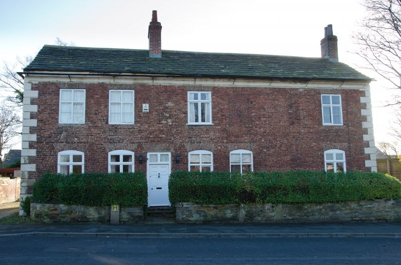
House, Earlier C18, incorporating parts of earlier (C17) building altered.
Mostly handmade brown brick in stretcher bond, with stone quoins, but earlier
part at right-hand end and rear of coursed sandstone blocks; stone slate
roof. L-plan, the earlier part forming a short receding wing at the
right-hand end; modern addition to rear of left end not included in the item.
Two storeys and 7 bays; rusticated long-and-short quoins, coved eaves; some
openings blocked or altered, but formerly all vertical-rectangular wide (a)
and narrow (b) in rhythmn a,a,b,a,a,b,a; former doorway in 5th at ground
floor altered as fixed window, former window in 3rd altered as doorway, 6th
blocked; and at 1st floor the 3rd, 5th and 6th blocked; gauged brick heads,
those at ground floor segmental and those above flat-arched; door with
fielded panels and 2-pane overlight; cross-windows with horizontal sliding
sashes in 4th at ground floor, 2nd and 6th at 1st fioor. Chimney to ridge and
right gable. Left gable has small inserted window. Right-hand gable of
squared sandstone up to 1st floor, with dripmould, has a 3-light mullioned
window at ground floor towards the rear, with "DAIRY" inscribed in the
lintel, a 2-light window above lacking the mullion, Rear has a 3-light
window at ground floor, doorway with cambered lintel in re-entrant of wing.
Interior: middle bay has 2 longitudinal beams with stopped ovolo-moulding,
the left ends carried on large moulded wooden corbels suggesting position of
former inglenook bressumer; some C17 panelling In kitchen in rear wing
(?former parlour).
Listing NGR: SE3482028176
External links are from the relevant listing authority and, where applicable, Wikidata. Wikidata IDs may be related buildings as well as this specific building. If you want to add or update a link, you will need to do so by editing the Wikidata entry.


Other nearby listed buildings