Approximate Location Map
Large Map »
Latitude: 53.5987 / 53°35'55"N
Longitude: -1.6125 / 1°36'45"W
OS Eastings: 425739
OS Northings: 411420
OS Grid: SE257114
Mapcode National: GBR KV5T.PP
Mapcode Global: WHCBB.6TD0
Plus Code: 9C5WH9XP+FX
Entry Name: Milepost at Juntion with Park Road
Listing Date: 15 August 1985
Grade: II
Source: Historic England
Source ID: 1185054
English Heritage Legacy ID: 341330
ID on this website: 101185054
Location: Clayton West, Kirklees, West Yorkshire, HD8
County: Kirklees
Civil Parish: Denby Dale
Built-Up Area: Clayton West
Traditional County: Yorkshire
Lieutenancy Area (Ceremonial County): West Yorkshire
Church of England Parish: Clayton West with High Hoyland All Saints
Church of England Diocese: Leeds
Tagged with: Milestone
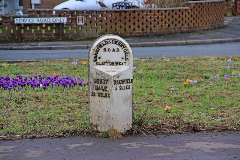
SE 21 SE WAKEFIELD ROAD
SE 2585 1141 (South Side)
Clayton West
2/58 Milepost at junction
with Park Road
II
Milepost. Late C19. Cast iron triangular front with round top,
on stone post. WAKEFIELD & DENBY DALE
ROAD
CLAYTON WEST
DENBY WAKEFIELD
DALE 8 MILES
2½ MILES
Listing NGR: SE2573911420
External links are from the relevant listing authority and, where applicable, Wikidata. Wikidata IDs may be related buildings as well as this specific building. If you want to add or update a link, you will need to do so by editing the Wikidata entry.


Other nearby listed buildings
