Approximate Location Map
Large Map »
Latitude: 53.7186 / 53°43'6"N
Longitude: -2.1008 / 2°6'2"W
OS Eastings: 393444
OS Northings: 424691
OS Grid: SD934246
Mapcode National: GBR FTRF.ZQ
Mapcode Global: WHB8C.PSTM
Plus Code: 9C5VPV9X+CM
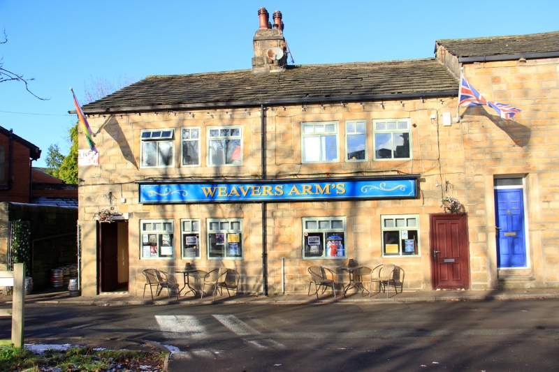
Entry Name: Weavers Arms Public House
Listing Date: 22 February 1984
Grade: II
Source: Historic England
Source ID: 1185476
English Heritage Legacy ID: 339016
Also known as: Weavers Arms, Todmorden
Weavers Arms
ID on this website: 101185476
Location: Hole Bottom, Calderdale, West Yorkshire, OL14
County: Calderdale
Civil Parish: Todmorden
Built-Up Area: Todmorden
Traditional County: Yorkshire
Lieutenancy Area (Ceremonial County): West Yorkshire
Church of England Parish: Todmorden St Mary
Church of England Diocese: Leeds
Tagged with: Pub
SD 9324 TODMORDEN (former M.B.) BLIND LANE
6/35 Weavers Arms Public House
II
Public House. Early C19. Watershot masonry, stone slate roof. Quoins.
2 storeys. 2 bays of 3-light flat faced mullioned windows to both floors.
2 doorways with monolithic jambs. Large stack to ridge.
Listing NGR: SD9344424691
External links are from the relevant listing authority and, where applicable, Wikidata. Wikidata IDs may be related buildings as well as this specific building. If you want to add or update a link, you will need to do so by editing the Wikidata entry.


Other nearby listed buildings
