Approximate Location Map
Large Map »
Latitude: 51.2433 / 51°14'35"N
Longitude: 0.3834 / 0°23'0"E
OS Eastings: 566453
OS Northings: 152042
OS Grid: TQ664520
Mapcode National: GBR NPX.V2H
Mapcode Global: VHJMJ.L0JQ
Plus Code: 9F3269VM+88
Entry Name: St Michaels Cottage
Listing Date: 19 April 1985
Grade: II
Source: Historic England
Source ID: 1185509
English Heritage Legacy ID: 178830
ID on this website: 101185509
Location: Tonbridge and Malling, Kent, TN12
County: Kent
District: Tonbridge and Malling
Civil Parish: East Peckham
Traditional County: Kent
Lieutenancy Area (Ceremonial County): Kent
Church of England Parish: East Peckham
Church of England Diocese: Rochester
Tagged with: Cottage
TQ 65 SE EAST PECKHAM ROYDON HALL ROAD (west
side)
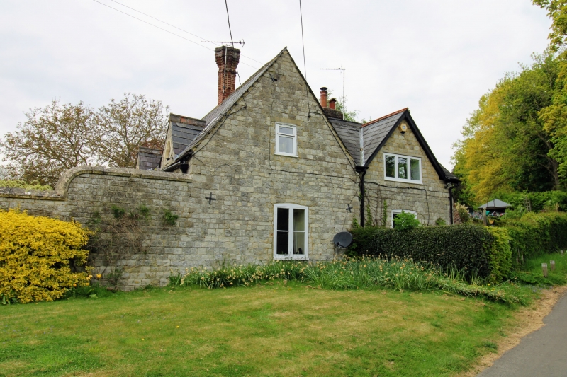
2/53 St Michael's Cottage
-
GV II
Stables, now partly converted into cottage. Mid C19 . Coursed
rubble stone with slate roof. 3 small gables to south with trefoil windows.
Neo-Elizabethan ridge stack. 1 storey, 4 windows with 3 small casements to
left and 1 large casement to right. Included for group value.
Listing NGR: TQ6645352042
External links are from the relevant listing authority and, where applicable, Wikidata. Wikidata IDs may be related buildings as well as this specific building. If you want to add or update a link, you will need to do so by editing the Wikidata entry.


Other nearby listed buildings
