Latitude: 51.7188 / 51°43'7"N
Longitude: -1.9825 / 1°58'56"W
OS Eastings: 401307
OS Northings: 202235
OS Grid: SP013022
Mapcode National: GBR 2PL.3MQ
Mapcode Global: VHB2Q.L295
Plus Code: 9C3WP299+G2
Entry Name: Hexagon
Listing Date: 14 June 1948
Grade: II*
Source: Historic England
Source ID: 1187402
English Heritage Legacy ID: 365106
ID on this website: 101187402
Location: Cirencester, Cotswold, Gloucestershire, GL7
County: Gloucestershire
District: Cotswold
Civil Parish: Cirencester
Traditional County: Gloucestershire
Lieutenancy Area (Ceremonial County): Gloucestershire
Church of England Parish: Cirencester St John the Baptist
Church of England Diocese: Gloucester
Tagged with: Folly
CIRENCESTER
SP0102 CIRENCESTER PARK
578-1/3/358 Hexagon
14/06/48
GV II*
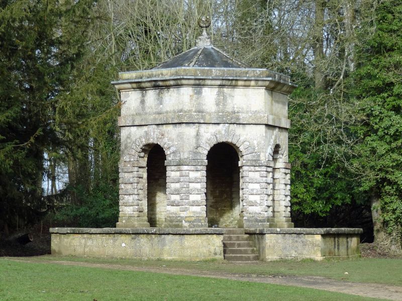
Park building. c1736, designed by Lord Bathurst. Limestone
ashlar with vermiculated dressings; rear wall of limestone
rubble. Welsh slate roof with limestone ball finial at apex.
The building is in plan an irregular hexagon with the rear
wall slightly wider than the others.
Single storey with round-headed openings with vermiculated
rusticated surrounds and impost blocks to 3 front faces and
similar blocked openings to left and right. Ashlar stylobate,
band course and cornice with single bold cyma recta moulding;
ashlar blocking course. The entire building is raised on a
plinth approximately 3' high and projecting approximately 5'
around building with ashlar retaining wall with shallow plinth
and stone coping; 5 steps up to centre front.
INTERIOR has been stripped of plaster and has no ceiling.
Concrete screed floor. C20 iron benches in round-headed niche
in rear wall and blocked arches to left and right. C20 roof
structure.
The Hexagon appears on Rudder's plan of 1779 as the meeting
place of 3 rides and 3 smaller walks and then enjoyed views of
the Horse Temple (qv - now moved) and Hartley's Temple (now
gone). The 2 arches to left and right were possibly blocked
when the Broad Ride was extended eastwards past the Hexagon
after l779.
(Rudder S: The History and Antiquities of Cirencester (Plan of
park): Cirencester: 1780-; EH Gardens Register: Gloucester:
Grade I: London: 1986-).
Listing NGR: SP0130702235
External links are from the relevant listing authority and, where applicable, Wikidata. Wikidata IDs may be related buildings as well as this specific building. If you want to add or update a link, you will need to do so by editing the Wikidata entry.


Other nearby listed buildings