Approximate Location Map
Large Map »
Latitude: 51.2323 / 51°13'56"N
Longitude: -0.5761 / 0°34'34"W
OS Eastings: 499510
OS Northings: 149092
OS Grid: SU995490
Mapcode National: GBR FCJ.R4X
Mapcode Global: VHFVM.Y9S3
Plus Code: 9C3X6CJF+WH
Entry Name: Millmead House
Listing Date: 1 May 1953
Grade: II
Source: Historic England
Source ID: 1188094
English Heritage Legacy ID: 289009
ID on this website: 101188094
Location: Guildford, Surrey, GU2
County: Surrey
District: Guildford
Town: Guildford
Electoral Ward/Division: Friary and St Nicolas
Parish: Non Civil Parish
Built-Up Area: Guildford
Traditional County: Surrey
Lieutenancy Area (Ceremonial County): Surrey
Church of England Parish: Guildford St Nicolas
Church of England Diocese: Guildford
Tagged with: House
SU 99 49SE & SU 99 49SW GUILDFORD MILLMEAD
(West Side)
8/144 & 7/144 Millmead House
1/5/53
II
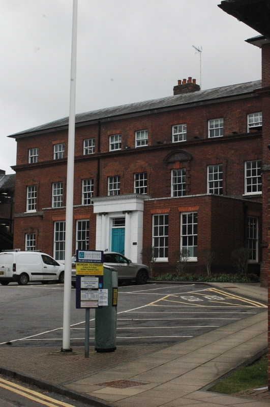
House, now council offices. Late C17 with C18 alterations, extended in C19 and
C20 in similar style. Deep red/brown brick to centre, orange-brown brick to
left, red brick to right. Low-pitched hipped slate roofs. Original house of
rectangular plan, now L-shaped with extensions projecting forward to right. Two
storeys and attics with stacks to rear left of centre and to right end. Original
house five bays wide with brick modillion eaves cornice, now to base of attic
storey. Blue header plat band across the ground floor plinth below. Five 6-
pane attic sash windows under gauged-brick heads, some renewed, with five 12-
pane glazing-bar sash windows on the first floor. Centre window on the first
floor in Gibbs style, block-rusticated surround under segmental pediment with
blue headers in tympanum and keystone to centre, remaining first floor windows
in raised shouldered surrounds with keystones over. Ground floor projects below
with stone-coped parapet. Two large, 12-pane glazing-bar sash windows either
side of central rendered and projecting frontispiece. Modillioned entablature
over attached 3/4 Roman Ionic columns and channelled outer piers. Paired doors
of fielded panels with egg and dart mouldings and margin tracery to the transom-
light above. Extension of four bays to left with similar fenestration, one bay
addition to the right with two attic sashes and one window on the first floor.
End wing to right projects with 3 windows across the front, 4 windows deep.
Rear:- Further extensions not of special interest.
Interiors:- Fine C18 turned baluster staircase of some quality, C18 and C19
fielded-panel doors in architrave without string surrounds. Some ceiling coving.
Most impressive room, on the first floor, is approached up the main stair and was
the former Rural District Council Chamber.
Listing NGR: SU9948649073
External links are from the relevant listing authority and, where applicable, Wikidata. Wikidata IDs may be related buildings as well as this specific building. If you want to add or update a link, you will need to do so by editing the Wikidata entry.


Other nearby listed buildings
