Approximate Location Map
Large Map »
Latitude: 52.0979 / 52°5'52"N
Longitude: -1.2267 / 1°13'36"W
OS Eastings: 453068
OS Northings: 244676
OS Grid: SP530446
Mapcode National: GBR 8TX.GP4
Mapcode Global: VHCW3.PJBM
Plus Code: 9C4W3QXF+58
Entry Name: Three Conies Inn
Listing Date: 22 May 1985
Grade: II
Source: Historic England
Source ID: 1191017
English Heritage Legacy ID: 234502
Also known as: The Three Conies, Banbury
Three Conies
ID on this website: 101191017
Location: Thorpe Mandeville, West Northamptonshire, OX17
County: West Northamptonshire
Civil Parish: Thorpe Mandeville
Traditional County: Northamptonshire
Lieutenancy Area (Ceremonial County): Northamptonshire
Church of England Parish: Thorpe Mandeville St John the Baptist
Church of England Diocese: Peterborough
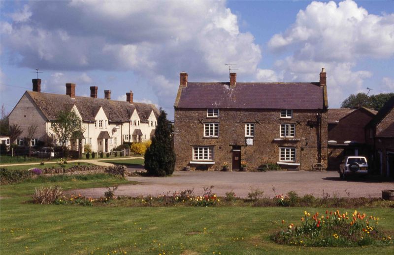
THORPE MANDEVILLE MAIN STREET
SP54SW (East side)
7/228 Three Conies Inn
- II
House, now public house. C17/C18, remodelled early C19. Coursed limestone and
ironstone rubble, slate roof, brick stacks. 2 storeys, attic and cellar, 3 bays.
Doorway left of centre has wood lintel, rectangular overlight and C20 ribbed
plank door. Window to left with wood lintel, rectangular overlight and C20
ribbed plank door. 4-light window to right and 3-light casement windows with
wood lintels in outer bay on first floor, with 2-light window in centre. 2-light
windows with wood lintels and iron casements in attic. Coped gable ends with
kneelers. Iron sundial to right of entrance with date 1622. Interior: Stop
chamfered spine beans, open fireplace.
Listing NGR: SP5306844676
External links are from the relevant listing authority and, where applicable, Wikidata. Wikidata IDs may be related buildings as well as this specific building. If you want to add or update a link, you will need to do so by editing the Wikidata entry.


Other nearby listed buildings
