Approximate Location Map
Large Map »
Latitude: 52.8941 / 52°53'38"N
Longitude: -1.8724 / 1°52'20"W
OS Eastings: 408678
OS Northings: 332972
OS Grid: SK086329
Mapcode National: GBR 38R.FG2
Mapcode Global: WHCFP.6JM4
Plus Code: 9C4WV4VH+M2
Entry Name: Cemetery Chapels
Listing Date: 26 March 1973
Grade: II
Source: Historic England
Source ID: 1191127
English Heritage Legacy ID: 272942
ID on this website: 101191127
Location: Balance Hill, East Staffordshire, ST14
County: Staffordshire
District: East Staffordshire
Civil Parish: Uttoxeter
Traditional County: Staffordshire
Lieutenancy Area (Ceremonial County): Staffordshire
Church of England Parish: Uttoxeter St Mary Virgin
Church of England Diocese: Lichfield
Tagged with: Cemetery chapel
STAFFORD ROAD
1.
1756
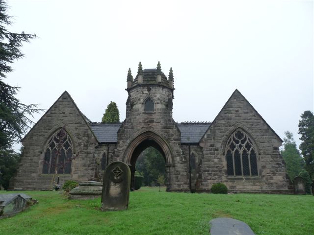
Cemetery Chapels
SK 03 SE 2/97
II
2.
Circa 1870. Gothic style. Ashlar with slate roofs. 2 small chapels (one
now used as a store) linked by an arched covered-way and surmounted by an
octagonal tower and spire, truncated as a result of a fire. Perhaps by William
Sugden, as similar to his cemetery chapels at Leek.
Listing NGR: SK0867832972
External links are from the relevant listing authority and, where applicable, Wikidata. Wikidata IDs may be related buildings as well as this specific building. If you want to add or update a link, you will need to do so by editing the Wikidata entry.


Other nearby listed buildings
