Approximate Location Map
Large Map »
Latitude: 53.502 / 53°30'7"N
Longitude: -1.3454 / 1°20'43"W
OS Eastings: 443520
OS Northings: 400788
OS Grid: SE435007
Mapcode National: GBR MW1Y.JC
Mapcode Global: WHDD5.97LM
Plus Code: 9C5WGM23+QV
Entry Name: Church House
Listing Date: 21 August 1985
Grade: II
Source: Historic England
Source ID: 1192655
English Heritage Legacy ID: 335559
ID on this website: 101192655
Location: Wath upon Dearne, Rotherham, South Yorkshire, S63
County: Rotherham
Electoral Ward/Division: Wath
Parish: Non Civil Parish
Built-Up Area: Wath upon Dearne
Traditional County: Yorkshire
Lieutenancy Area (Ceremonial County): South Yorkshire
Church of England Parish: Wath Upon Dearne All Saints
Church of England Diocese: Sheffield
Tagged with: House
SE40SW WATH UPON DEARNE MONTGOMERY SQUARE
(south side)
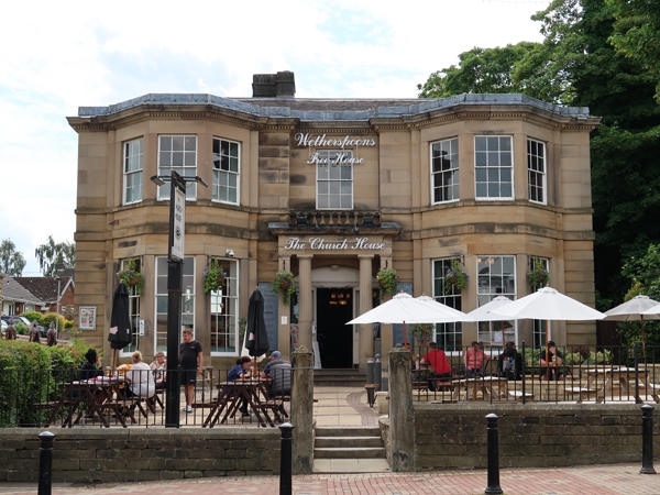
2/50 Church House
GV II
House now public house. c1810 for William Carr (Fleming and Hird).
Ashlar sandstone facade; coursed, squared sandstone elsewhere;
graduated Welsh slate roof. Deep plan with wing to rear left.
2 storeys, symmetrical 3-bay front, 3-storey wing. Plinth, rusticated
ground floor. Recessed central bay with 3 stone steps to open stone
porch: 2 part-fluted Doric columns in antis, mutule cornice; part-glazed
doors beneath segmental arch. Outer bays break forward and have plain
ashlar, 2-storey canted bay-windows each with 3 unequal 15-pane sashes
(altered upper sash frames to left bay). Band at porch cornice level.
1st-floor sill band. All windows have sashes with glazing bars; central
window behind low balustrade. Dentils to continuous cornice, blocking
course. Hipped roof with lead flashings. Ridge stack to left, end stack
to right. Doric stone porch to left return.
A. Fleming and S. Hird, Wath-upon-Dearne As It Was, 1982, plate 24.
Listing NGR: SE4352000788
External links are from the relevant listing authority and, where applicable, Wikidata. Wikidata IDs may be related buildings as well as this specific building. If you want to add or update a link, you will need to do so by editing the Wikidata entry.


Other nearby listed buildings
