Latitude: 53.4178 / 53°25'4"N
Longitude: -1.2167 / 1°13'0"W
OS Eastings: 452154
OS Northings: 391510
OS Grid: SK521915
Mapcode National: GBR MXYX.CJ
Mapcode Global: WHDDM.8CV5
Plus Code: 9C5WCQ9M+48
Entry Name: Farmbuilding Approximately 20 Metres to East of Home Farmhouse
Listing Date: 1 April 1987
Grade: II
Source: Historic England
Source ID: 1192683
English Heritage Legacy ID: 335908
ID on this website: 101192683
Location: Hooton Levitt, Rotherham, South Yorkshire, S66
County: Rotherham
Civil Parish: Hooton Levitt
Traditional County: Yorkshire
Lieutenancy Area (Ceremonial County): South Yorkshire
Church of England Parish: Maltby
Church of England Diocese: Sheffield
Tagged with: Agricultural structure
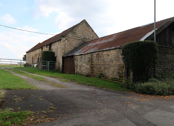
HOOTON LEVITT HOOTON LEVITT SK59SW 3/33 Farmbuilding approximately 20 metres to east of Home Farmhouse II Cowhouses and stables with hayloft. Early C18 with later alterations. Coursed limestone rubble, stone slate eaves courses to pantile roof. 2 storeys, 7 bays. Large quoins. Near-central doorway with brick relieving arch flanked: on left, by square-headed doorway, external stone steps incoporating dog-kennel beyond: on right, by a flat-arched doorway (now with slatted casement) with door in ashlar surround on right and doorway beyond with segmental brick arch. 1st floor: 2 segmental-arched casements near centre of range; boarded door to landing of external steps on left; boarded loft door to right end of range. Shaped kneelers and ashlar gable copings. Rear: Later brick steps to loft doorway on right. Attached single-storey farmbuildings not of special interest.
Listing NGR: SK5215491510
External links are from the relevant listing authority and, where applicable, Wikidata. Wikidata IDs may be related buildings as well as this specific building. If you want to add or update a link, you will need to do so by editing the Wikidata entry.


Other nearby listed buildings