Approximate Location Map
Large Map »
Latitude: 53.5285 / 53°31'42"N
Longitude: -1.1729 / 1°10'22"W
OS Eastings: 454927
OS Northings: 403859
OS Grid: SE549038
Mapcode National: GBR NW7M.WV
Mapcode Global: WHDD1.YKNT
Plus Code: 9C5WGRHG+CV
Entry Name: Boathouse at North End of Upper Fish Pond
Listing Date: 11 April 1986
Grade: II
Source: Historic England
Source ID: 1192774
English Heritage Legacy ID: 334566
ID on this website: 101192774
Location: Cusworth Park, Cusworth, Doncaster, South Yorkshire, DN5
County: Doncaster
Civil Parish: Sprotbrough and Cusworth
Built-Up Area: Bentley
Traditional County: Yorkshire
Lieutenancy Area (Ceremonial County): South Yorkshire
Church of England Parish: Doncaster St Leonard and St Jude with Scawthorpe St Luke
Church of England Diocese: Sheffield
Tagged with: Boathouse
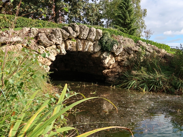
SE5493 0385 SPROTBROUGH CUSWORTH PARK
7/145 Boathouse at north end
of Upper Fish Pond
II
Boathouse. Mid C18 for the Wrightson family of Cusworth Hall (q.v.).
Limestone rubble and boulders. In grotto style. Segmentally-arched entrance
to round-ended, vaulted recess admitting water from the landscape lake. Arch is
of 2 orders of roughly-hewn.boulders. Vault rusticated by pendant through-stones.
Upper surface firms landscaped mound.
Probably a part of the 1763 landscape scheme carried out by Richard Woods,
surveyor of Chertsey in Surrey (Smith, p17).
G. Smith, An Illustrated History of Cusworth Hall and the Battie-Wrightson Family,
1976 ed.
Listing NGR: SE5492703859
External links are from the relevant listing authority and, where applicable, Wikidata. Wikidata IDs may be related buildings as well as this specific building. If you want to add or update a link, you will need to do so by editing the Wikidata entry.


Other nearby listed buildings
