Approximate Location Map
Large Map »
Latitude: 53.3489 / 53°20'55"N
Longitude: -1.2245 / 1°13'28"W
OS Eastings: 451720
OS Northings: 383835
OS Grid: SK517838
Mapcode National: GBR MYWQ.P7
Mapcode Global: WHDF0.5350
Plus Code: 9C5W8QXG+H5
Entry Name: Laurel Bank
Listing Date: 15 October 1986
Grade: II
Source: Historic England
Source ID: 1192805
English Heritage Legacy ID: 335822
ID on this website: 101192805
Location: South Anston, Rotherham, South Yorkshire, S25
County: Rotherham
Civil Parish: North and South Anston
Built-Up Area: Dinnington
Traditional County: Yorkshire
Lieutenancy Area (Ceremonial County): South Yorkshire
Church of England Parish: Anston St James
Church of England Diocese: Sheffield
Tagged with: Architectural structure
NORTH AND SOUTH ANSTON SHEFFIELD ROAD
SK58SW
(south side),
South Anston
No 33 (Laurel Bank)
5/72 and No 33A
II
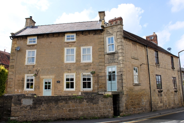
House, extended and now 2 dwellings. Mid-late C18, C19 additions and alterations.
Deeply-coursed dressed limestone, Welsh slate roof. 3 storeys, now 4 windows
to 1st floor. Original house: plinth, large chamfered quoins. Doorway to
left of centre has C20 part-glazed door in architrave. Casement to left beneath
flat arch with keystone, 2 windows to right of door have lowered sills and 18-
pane sashes, that on right an insertion with keystone cut on lintel; ledges
over the keystones. 1st floor: casement to bay 1 otherwise sashes with glazing
bars with heads as ground-floor windows. 2nd floor: shorter centre-pivoted
casements with glazing bars, no inserted window on right. Shaped kneelers,
gable copings. Corniced ashlar end stack on right, renewed end stack on left.
Single-bay addition on right with door to No 33A is angled out from the facade
and has large quoins on right and 1st-floor sash with glazing bars in square-
faced surround; embattled parapet. Right return: 1 bay with sash with glazing
bars beneath blind window having ashlar surround. Tiled roof with brick ridge
stack at junction with adjoining property (not of special interest).
Listing NGR: SK5172083835
External links are from the relevant listing authority and, where applicable, Wikidata. Wikidata IDs may be related buildings as well as this specific building. If you want to add or update a link, you will need to do so by editing the Wikidata entry.


Other nearby listed buildings
