Approximate Location Map
Large Map »
Latitude: 51.6312 / 51°37'52"N
Longitude: 0.3225 / 0°19'21"E
OS Eastings: 560839
OS Northings: 195038
OS Grid: TQ608950
Mapcode National: GBR YG.V9K
Mapcode Global: VHHN3.J8VD
Plus Code: 9F32J8JF+F2
Entry Name: Toll Bar Cottage
Listing Date: 21 October 1958
Last Amended: 9 December 1994
Grade: II
Source: Historic England
Source ID: 1197194
English Heritage Legacy ID: 373392
ID on this website: 101197194
Location: Shenfield, Brentwood, Essex, CM15
County: Essex
District: Brentwood
Electoral Ward/Division: Shenfield
Parish: Non Civil Parish
Built-Up Area: Brentwood
Traditional County: Essex
Lieutenancy Area (Ceremonial County): Essex
Church of England Parish: Shenfield St Mary the Virgin
Church of England Diocese: Chelmsford
Tagged with: Cottage
BRENTWOOD
TQ69NW CHELMSFORD ROAD, Shenfield
723-1/6/268 (North West side)
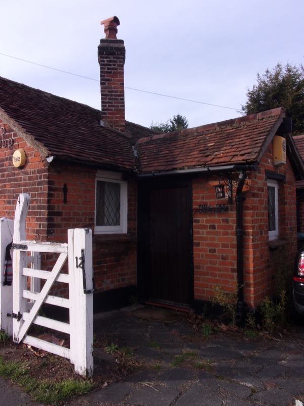
21/10/58 Toll Bar Cottage
(Formerly Listed as:
CHELMSFORD ROAD, Shenfield
Old Toll Bar Cottage)
II
Toll house. Early C18, extended in C19 and C20. Timber-framed,
clad with red brick in Flemish bond, roofed with handmade red
clay tiles. C-plan with wings to SW and NW, original stack to
SE enclosed by lean-to extension, with C20 gabled porch
beyond. C19 and C20 extensions to NE. Single storey. All
windows are C20 casements. C20 plain boarded door. Some
weatherboarding on SW gable. Diamond shaft. `A.D. 1700' in C20
applied letters and numerals on SW elevation. The section of
the Great Essex Road from Shenfield to Ingatestone Town was
the first road in Essex to be turnpiked, by the Essex Trust in
1695. The turnpike is shown in Chapman and Andre's road map of
1777, and in J Cary, Survey of the High Roads from London.
(Booker J: Essex and the Industrial Revolution: 1974-: 18,
101-2, 116; Cary J: Survey of th High Roads from London:
1790-).
Listing NGR: TQ6083995038
External links are from the relevant listing authority and, where applicable, Wikidata. Wikidata IDs may be related buildings as well as this specific building. If you want to add or update a link, you will need to do so by editing the Wikidata entry.


Other nearby listed buildings
