Latitude: 51.8669 / 51°52'1"N
Longitude: -1.6507 / 1°39'2"W
OS Eastings: 424147
OS Northings: 218765
OS Grid: SP241187
Mapcode National: GBR 5S2.X21
Mapcode Global: VHBZL.BBPN
Plus Code: 9C3WV88X+QP
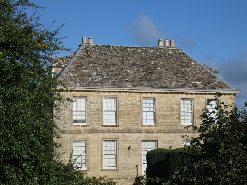
Entry Name: Fifield House
Listing Date: 15 May 1989
Grade: II*
Source: Historic England
Source ID: 1198985
English Heritage Legacy ID: 253982
ID on this website: 101198985
Location: Fifield, West Oxfordshire, OX7
County: Oxfordshire
District: West Oxfordshire
Civil Parish: Fifield
Traditional County: Oxfordshire
Lieutenancy Area (Ceremonial County): Oxfordshire
Church of England Parish: Fifield with Idbury
Church of England Diocese: Oxford
Tagged with: Building
FIFIELD SP2418-2518 19/95 Fifield House
GV II*
Farmhouse. Late C17 or possibly early C18 with later additions and alterations. Regularly coursed and dressed limestone with ashlar dressings and quoin strips; hipped stone slate roof with modillion eaves cornice. 2 storeys and attic with moulded floor band and moulded plinth to semi-basement. 5-window front; 18-paned glazing bar sashes in moulded surrounds. Central entrance; half-glazed double doors with decorated rectangular overlight approached by semi-circular flight of steps with ball finials at each end of ramped coping and small pilastered piers flanking door. Semi-basement has 2-light chamfered mullion windows directly below ground-floor sashes, inner right replaced by C20 window, with narrow rectangular chamfered windows to each side of steps. Left return has blind windows in moulded surrounds to each floor, 2-light mullion window to semi-basement and flat-roofed dormer in bottom of roof slope. Right return same except that windows have glazing bar sashes painted in imitation and it has a C20 French casement to semi-basement. Stepped external lateral stack to rear on right and similar integral stack to left with hip-roofed staircase projection between. This has 2-light chamfered mullion windows to semi-basement and to second floor with fixed-light window in earlier surround on level between. Lower fiat-roofed range attached to one side. Gabled dormers in roof slope of main range. Gabled service ranges attached at right-angles to rear on left with C20 range running at right-angles to left towards farmyard. Interior. C17/early C18 dog-leg staircase at back of central hall in hip-roofed projection rises from semi-basement and continues to attic: turned balusters to open string, moulded handrail and square newels. Left ground-floor room has plaster cornice with egg and dart moulding. Bolection moulded fireplace to room above. Wide floor boards to ground floor, first floor and attic and 2-panel doors with H-hinges throughout. (Buildings of England: Oxfordshire: p603) [2539]
Listing NGR: SP2414718765
External links are from the relevant listing authority and, where applicable, Wikidata. Wikidata IDs may be related buildings as well as this specific building. If you want to add or update a link, you will need to do so by editing the Wikidata entry.


Other nearby listed buildings