Approximate Location Map
Large Map »
Latitude: 51.6922 / 51°41'32"N
Longitude: -1.6444 / 1°38'39"W
OS Eastings: 424678
OS Northings: 199335
OS Grid: SU246993
Mapcode National: GBR 5V6.YXV
Mapcode Global: VHC0C.GQ1L
Plus Code: 9C3WM9R4+V7
Entry Name: Home Farmhouse
Listing Date: 12 September 1955
Grade: II
Source: Historic England
Source ID: 1199119
English Heritage Legacy ID: 253814
ID on this website: 101199119
Location: Kelmscott, West Oxfordshire, GL7
County: Oxfordshire
District: West Oxfordshire
Civil Parish: Kelmscott
Traditional County: Oxfordshire
Lieutenancy Area (Ceremonial County): Oxfordshire
Church of England Parish: Broadwell with Kelmscott
Church of England Diocese: Oxford
Tagged with: Farmhouse
KELMSCOTT
SU2499-2599
10/62 Home Farmhouse
12.9.55
- II
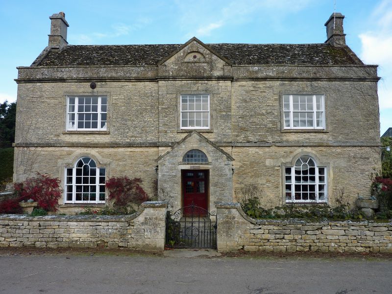
Farmhouse. Mid-C18 remodelling of C17 or earlier building; later additions and
alterations. Roughly coursed limestone rubble with ashlar dressings, formerly
roughcast to front; stone slate roofs with coped verges and parapet to main
range. L-plan comprising C18 front with long gabled range at right-angles to
rear on right; late C19/early C20 additions in angle between. 2 storeys with
plinth, floor band and moulded eaves cornice. 1:1:1 bays, centre slightly
projecting with open pediment to parapet; glazing bar sashes in stone surrounds,
16-paned to centre on first floor, tripartite to outer bays and Venetian to
ground floor. Blind lunette to open pediment with defaced Sun Fire Insurance
plate. Central entrance; mid-C20 gabled rubblestone porch over recessed 6-panel
door (upper 4 panels now glazed) with wreathed and radiating fanlight. Integral
ashlar end stacks have moulded dripstones and capping. Range at right-angles to
rear has 3-light chamfered mullion window directly below eaves to far left and
2-light mullion windows to 2 gabled false dormers to right. Ground floor has
narrow C19 casement to far left and 4-light segmental-headed casement to left of
centre. Three-light mullion-window to right with C20 lean-to (not of special
architectural interest) to right. Prominent ashlar ridge stack with dripstone
and capping to centre and corbelled external end stack to right, apparently
cutting possibly reset mullioned window. Further 2- and 3-light mullion windows
to garden side. Interior. Staircase in stone-flagged central entrance hall has
stick balusters, carved open string and wreathed handrail. Chamfered ceiling
beams in ground-floor rooms. Panelled doors. Late C19/early C20 addition in
angle to rear is not of special architectural interest.
(Buildings of England: Oxfordshire: p667)
[2357]
Listing NGR: SU2467899335
External links are from the relevant listing authority and, where applicable, Wikidata. Wikidata IDs may be related buildings as well as this specific building. If you want to add or update a link, you will need to do so by editing the Wikidata entry.


Other nearby listed buildings
