Approximate Location Map
Large Map »
Latitude: 53.8695 / 53°52'10"N
Longitude: -1.8353 / 1°50'7"W
OS Eastings: 410924
OS Northings: 441490
OS Grid: SE109414
Mapcode National: GBR HRMP.GM
Mapcode Global: WHC8V.SZ6Y
Plus Code: 9C5WV597+RV
Entry Name: Hill Top Farmhouse and Attached Archway
Listing Date: 18 October 1985
Grade: II
Source: Historic England
Source ID: 1199512
English Heritage Legacy ID: 337920
ID on this website: 101199512
Location: Micklethwaite, Bradford, West Yorkshire, BD16
County: Bradford
Civil Parish: Bingley
Traditional County: Yorkshire
Lieutenancy Area (Ceremonial County): West Yorkshire
Church of England Parish: Bingley All Saints
Church of England Diocese: Leeds
Tagged with: Farmhouse
SE14SW BINGLEY DRAKE HILL
SE109414 (west side)
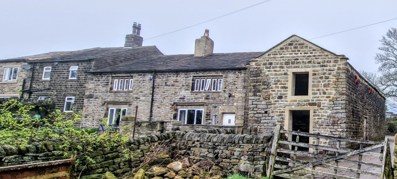
2/62 Hill Top Farmhouse
and attached archway
II
House and attached archway. Mid C17. Hammer-dressed stone, dressed
quoins, stone slate roof. 2 storeys. 2-cell, double-depth direct
entry plan. All are double-chamfered mullioned windows. Ground floor
front has former 4-light and 5-light windows with hoodmoulds, mullions
removed and with lowered sills (modern glazing). Above, a 4-light and
a 5-light window. Doorway to right-hand end has composite jambs and
lintel with sunken recess (for date?) and chamfered surround. Coped
gable with kneelers to right. Central stack to ridge (rendered). Rear
has 3 mullioned windows all altered but formerly of 4 lights, 3 lights
and 3 lights. Steps lead to lst-floor doorway with tie-stone jambs,
possibly a taking-in door formerly connected with textile manufacture.
Stack to left-hand corner. Right-hand return wall has 3-light window
(blocked) and 2 of 2 lights above, all with hoodmoulds.
Attached to left-hand end of rear is semicircular-arched stone gateway
with composite jambs, much weathered but retaining Ionic capitals to
pilasters, moulded impost and ramped coping the apex surmounted by
ball finial. Inner rebate for gates.
Listing NGR: SE1092441490
External links are from the relevant listing authority and, where applicable, Wikidata. Wikidata IDs may be related buildings as well as this specific building. If you want to add or update a link, you will need to do so by editing the Wikidata entry.


Other nearby listed buildings
