Latitude: 51.8788 / 51°52'43"N
Longitude: -0.5604 / 0°33'37"W
OS Eastings: 499193
OS Northings: 221006
OS Grid: SP991210
Mapcode National: GBR F3T.35B
Mapcode Global: VHFRK.71LJ
Plus Code: 9C3XVCHQ+GR
Entry Name: 36, Wellhead Road
Listing Date: 25 January 1993
Grade: II
Source: Historic England
Source ID: 1200364
English Heritage Legacy ID: 350256
ID on this website: 101200364
Location: Church End, Central Bedfordshire, LU6
County: Central Bedfordshire
Civil Parish: Totternhoe
Built-Up Area: Totternhoe
Traditional County: Bedfordshire
Lieutenancy Area (Ceremonial County): Bedfordshire
Church of England Parish: Totternhoe
Church of England Diocese: St.Albans
Tagged with: Building
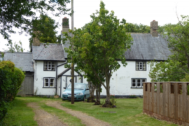
SP 9921 TOTTERNHOE WELLHEAD ROAD
CHURCH END
33/10014 No 36
- II
House. Circa mid C17, partly rebuilt and extended in C19. Timber-
framed; front and back walls painted Flemish bond brick. Steeply
pitched slate roof with gabled ends. Brick axial stack and gable
end stacks. Plan: 3-room plan with 1-room plan addition on left
(E) end built in C19 probably when the front and back walls were
rebuilt. The left room of the original house is heated from a
gable end stack, the centre room has an inserted axial stack and
the smaller right-hand (W) room is unheated. Exterior: 2 storeys.
Not quite symmetrical 3-window north front. C19 3-light casements
(ground floor right 2-light) with glazing bars; C20 porch on left
and plank door on right. 1-bay extension on left with C19 2 and
3-light casements with glazing bars. 3:1 bay rear (south)
elevation with similar windows and C20 conservatory on left. Shed
on west end and garage on east end. Interior: Centre and left
rooms have chamfered axial beams with run-out stops, the left
with exposed unchamfered joists, the centre with brick fireplace
with cambered chamfered lintel. Exposed timber frame partition
walls, closed trusses with tie-beams, collar and clasped purlins;
ceiled above collars.
Listing NGR: SP9919321006
External links are from the relevant listing authority and, where applicable, Wikidata. Wikidata IDs may be related buildings as well as this specific building. If you want to add or update a link, you will need to do so by editing the Wikidata entry.


Other nearby listed buildings