Approximate Location Map
Large Map »
Latitude: 53.4759 / 53°28'33"N
Longitude: -2.2513 / 2°15'4"W
OS Eastings: 383419
OS Northings: 397715
OS Grid: SJ834977
Mapcode National: GBR DHJ.6Z
Mapcode Global: WHB9G.DW6P
Plus Code: 9C5VFPGX+9F
Entry Name: Castlefield Information Centre
Listing Date: 17 May 1974
Grade: II
Source: Historic England
Source ID: 1200853
English Heritage Legacy ID: 388095
Also known as: Deansgate Free Library
Instituto Cervantes, Manchester
ID on this website: 101200853
Location: Manchester, Greater Manchester, M3
County: Manchester
Electoral Ward/Division: City Centre
Parish: Non Civil Parish
Built-Up Area: Manchester
Traditional County: Lancashire
Lieutenancy Area (Ceremonial County): Greater Manchester
Church of England Parish: Manchester St Ann
Church of England Diocese: Manchester
Tagged with: Building
MANCHESTER
SJ8397NW DEANSGATE
698-1/30/112 (West side)
17/05/74 Nos.322 TO 330 (Even)
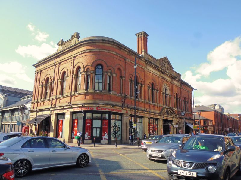
Castlefield Information Centre
(formerly Deansgate Free Library)
GV II
Formerly known as: Nos.322 TO 330 Deansgate Free Library
DEANSGATE.
Includes: No.2 LIVERPOOL ROAD.
Library over shops, now visitor' centre and urban studies
centre.1882, by George Meek; altered. Red brick with sandstone
dressings, slate roof. Rectangular plan with curved corners to
the front. Romanesque style. Two storeys (the upper much
higher), 7 bays including the corners; square stone piers to
ground floor, plus cast-iron columns at the corners, frieze
and cornice over ground floor, sill-band and panelled
pilasters to 1st floor, plain brick frieze, moulded cornice
with blocking course interrupted in the 3 centre bays by a
stone frieze, bracketed cornice and enriched parapet with
central carved pediment. The 4th bay at ground floor is an
open entrance to a lateral through-passage, furnished with
iron gates and with a segmental pediment above containing
carved figures; immediately to the right is a round-headed
doorway moulded in 2 orders, with shafts, and the other bays
have glazed screens. At 1st floor each bay has large stepped
triple window treated as an arcade of round-headed arches,
with stone shafts which have carved capitals, geometrical
glazing bars, and hoodmoulds, that over the main entrance with
a panelled arch-band above. Quadrantal corners with 5-bay
arcades carried round, and 2-bay returned ends in matching
style. Rear linked to former Higher Campfield Market Hall,
Liverpool Road (q.v.).
Listing NGR: SJ8341997715
External links are from the relevant listing authority and, where applicable, Wikidata. Wikidata IDs may be related buildings as well as this specific building. If you want to add or update a link, you will need to do so by editing the Wikidata entry.


Other nearby listed buildings
