Approximate Location Map
Large Map »
Latitude: 51.9974 / 51°59'50"N
Longitude: -0.9908 / 0°59'27"W
OS Eastings: 469380
OS Northings: 233701
OS Grid: SP693337
Mapcode National: GBR 9XQ.NBR
Mapcode Global: VHDT8.S213
Plus Code: 9C3XX2W5+XM
Entry Name: The Butcher's Arms
Listing Date: 21 November 1994
Grade: II
Source: Historic England
Source ID: 1201404
English Heritage Legacy ID: 377230
ID on this website: 101201404
Location: Buckingham, Buckinghamshire, MK18
County: Buckinghamshire
Civil Parish: Buckingham
Built-Up Area: Buckingham
Traditional County: Buckinghamshire
Lieutenancy Area (Ceremonial County): Buckinghamshire
Church of England Parish: Buckingham
Church of England Diocese: Oxford
Tagged with: Pub
BUCKINGHAM
SP6933 NELSON STREET
879-1/6/132 (East side)
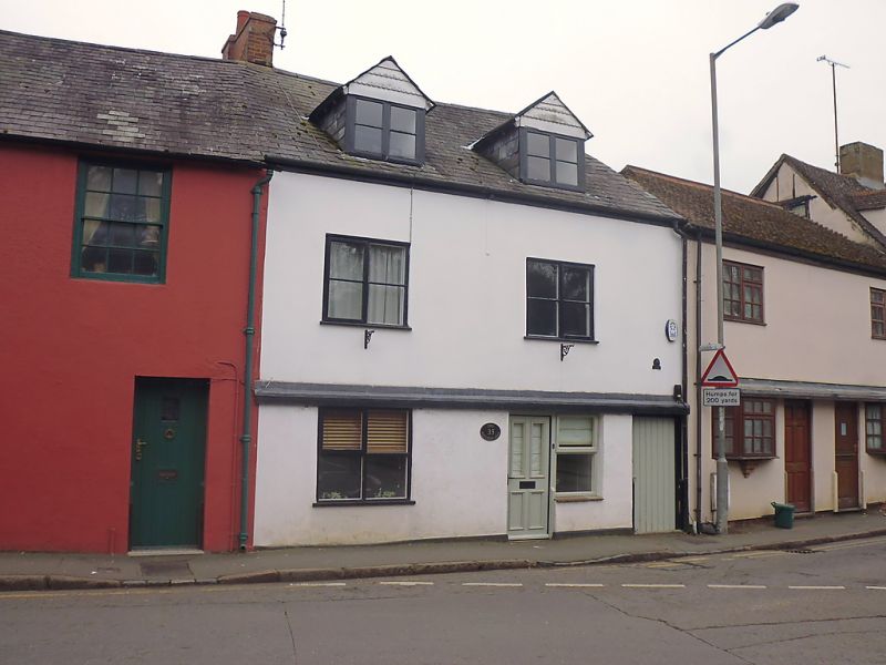
No.35
The Butcher's Arms
GV II
House, formerly public house. Probably C17, altered C19 and
C20. Rendered over timber-framing with slate roof and brick
end stack to left. L-plan. 2-storeys and attic; 2-window
range. C20 door to right of centre with window directly to
right and moulded wood surround. Passageway to far right.
2-light casement window to ground floor left. Similar windows
to 1st floor. 2-storey wing to rear left continued by
single-storey wing. Blocked doorway in passage with wood
lintel.
INTERIOR has massive chamfered spine beam to ground floor
front room, and stop-chamfered spine beam to ground floor back
room. Same room has small open fireplace with wood lintel. The
building reputed to have ceased to be a public house in 1935.
Listing NGR: SP6938333700
External links are from the relevant listing authority and, where applicable, Wikidata. Wikidata IDs may be related buildings as well as this specific building. If you want to add or update a link, you will need to do so by editing the Wikidata entry.


Other nearby listed buildings
