Approximate Location Map
Large Map »
Latitude: 50.2626 / 50°15'45"N
Longitude: -5.0528 / 5°3'10"W
OS Eastings: 182516
OS Northings: 44751
OS Grid: SW825447
Mapcode National: GBR ZF.XFYJ
Mapcode Global: FRA 089B.HBW
Plus Code: 9C2P7W7W+2V
Entry Name: 2-16, Walsingham Place
Listing Date: 29 December 1950
Grade: II
Source: Historic England
Source ID: 1201546
English Heritage Legacy ID: 377627
ID on this website: 101201546
Location: Truro, Cornwall, TR1
County: Cornwall
Civil Parish: Truro
Built-Up Area: Truro
Traditional County: Cornwall
Lieutenancy Area (Ceremonial County): Cornwall
Church of England Parish: St John and St Paul, Truro
Church of England Diocese: Truro
Tagged with: Building
TRURO
SW8244NE WALSINGHAM PLACE
880-1/7/317 Nos.2-16 (Consecutive)
29/12/50
GV II
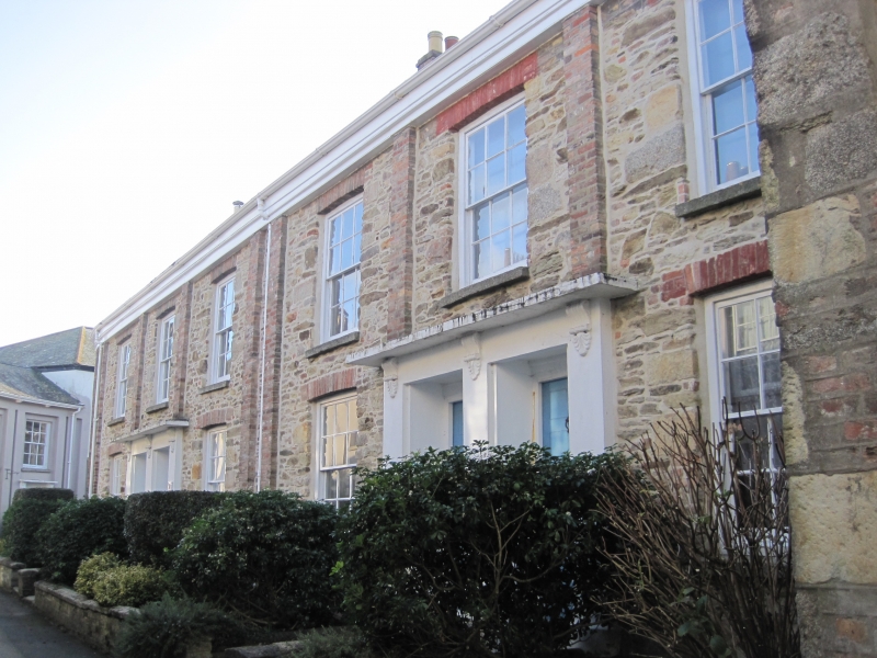
Planned street of 2 terraces of small town houses, many of
which are now offices. Early C19, possibly by Philip Sambell.
Nos 2-6 have original stucco, Nos 8-16 have been stripped to
reveal rubble walls with brick dressings; dry Delabole slate
to Nos 2-16 otherwise asbestos slate roofs with brick end
stacks; Nos 2-6 have projecting eaves on wooden brackets. 2
terraces of shallow-depth-plan houses built on a curve: Nos
2-6 & 16 each have 2 rooms at the front, a small service room
behind one room and stair hall behind the other; Nos 8-15
consists of 4 pairs of houses each with one room at the front.
2 storeys; symmetrical 1:1:1-bay fronts with 2 windows to each
of Nos 2-6 and to each pair and 3 windows to No.16. All have
original 12-pane hornless sashes; pairs of flat pilasters
dividing the recessed bays and doorcases with lions' heads as
corbels to flat hoods and panelled doors; No.16 has blocked
windows on the far right. INTERIORS: where inspected retain
most of their original carpentry, joinery and plasterwork.
(The Truro Buildings Research Group: River Street and its
Neighbourhood: Truro: 1980-).
Listing NGR: SW8251644751
External links are from the relevant listing authority and, where applicable, Wikidata. Wikidata IDs may be related buildings as well as this specific building. If you want to add or update a link, you will need to do so by editing the Wikidata entry.


Other nearby listed buildings
