Approximate Location Map
Large Map »
Latitude: 52.5857 / 52°35'8"N
Longitude: -2.1493 / 2°8'57"W
OS Eastings: 389982
OS Northings: 298669
OS Grid: SO899986
Mapcode National: GBR 17K.NG
Mapcode Global: WHBFY.Y8PK
Plus Code: 9C4VHVP2+77
Entry Name: Wolverhampton Grammar School
Listing Date: 3 February 1977
Grade: II
Source: Historic England
Source ID: 1201804
English Heritage Legacy ID: 378393
ID on this website: 101201804
Location: Merridale, Wolverhampton, West Midlands, WV3
County: City of Wolverhampton
Electoral Ward/Division: Park
Parish: Non Civil Parish
Built-Up Area: Wolverhampton
Traditional County: Staffordshire
Lieutenancy Area (Ceremonial County): West Midlands
Church of England Parish: Wolverhampton St Jude
Church of England Diocese: Lichfield
Tagged with: Independent school
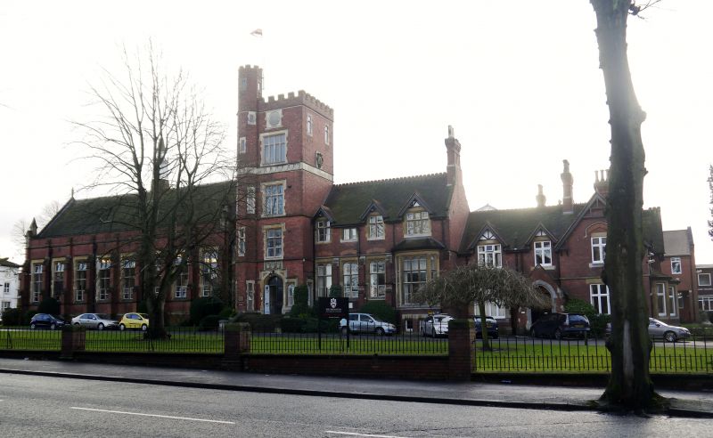
WOLVERHAMPTON
SO89NE COMPTON ROAD
895-1/4/76 (South side)
03/02/77 Wolverhampton Grammar School
II
School. 1875 with additions of 1890. By Giles and Gough. Brick
with ashlar dressings; tile roofs. Victorian Tudor Revival
style. Single-storey 8-window hall range; 4-storey entrance
tower with small 2-storey connecting bay to left and 4-window
range to right, formerly accommodation wing; former
headmaster's residence to right of 2 storeys; 3-window range
with 2-window return. Hall has weathered buttresses, end angle
buttresses with pinnacles; brick parapet and stone-coped
gables; architraved double-chamfered-mullioned windows with
Tudor heads to lights and 2 transoms; ventilation lantern to
ridge; return 5-light window with 4-centred head. Tower has
higher octagonal turret to left; Tudor-arched entrance with
label mould raised over shields and sidelight; sill courses to
1st and 2nd floors; frieze of shields above 2nd floor; top
embattled parapets; mullioned and transomed windows with
leaded glazing; top blocked roundel; right return has C18
cartouche; mullioned and transomed windows to block to left
and range to right, gableted to 1st floor; large canted bay
window to right end and gable-end stack. Headmaster's
residence has gabled projection to right; central entrance in
gabled porch with pointed arch; casemented windows; 1st floor
gablets; cross-axial stack; return similar. Rear similar, with
gabled single-storey and canted organ loft to hall; some later
wings. INTERIOR: hall has hammer-beam roof; some fielded
panelling; C20 balcony and panelling below; 2 hooded
fireplaces with armorial bearings; C20 stained glass and some
panels from St Andrew's, Undershaft, London; memorial plaques
from old school building. School was founded by Stephen Jenys
of the Merchant Taylors' Guild, 1515, and was later moved from
C18 building (dem) in town centre.
(The Buildings of England: Pevsner N: Staffordshire: London:
1974-: P.325).
Listing NGR: SO8998298669
External links are from the relevant listing authority and, where applicable, Wikidata. Wikidata IDs may be related buildings as well as this specific building. If you want to add or update a link, you will need to do so by editing the Wikidata entry.


Other nearby listed buildings
