Latitude: 51.4425 / 51°26'32"N
Longitude: -2.5743 / 2°34'27"W
OS Eastings: 360182
OS Northings: 171656
OS Grid: ST601716
Mapcode National: GBR CDP.PR
Mapcode Global: VH88V.B0FJ
Plus Code: 9C3VCCRG+X7
Entry Name: The Turnpike Public House
Listing Date: 4 March 1977
Grade: II
Source: Historic England
Source ID: 1201989
English Heritage Legacy ID: 378921
ID on this website: 101201989
Location: Knowle, Bristol, BS4
County: City of Bristol
Electoral Ward/Division: Windmill Hill
Parish: Non Civil Parish
Built-Up Area: Bristol
Traditional County: Somerset
Lieutenancy Area (Ceremonial County): Bristol
Church of England Parish: Knowle Holy Nativity
Church of England Diocese: Bristol
Tagged with: Pub
BRISTOL
ST316071 BATH ROAD, Totterdown 901-1/47/2038 (North side) 04/03/77 No.124 The Turnpike Public House
II
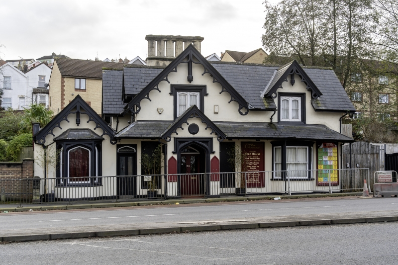
Public house. c1840. Render, limestone dressings, ashlar stack range and cross-gable and hip slate roof. Double-depth plan with 3 linked blocks. Tudor Revival style. 2 storeys, single storey left-hand side block; 4-window range. An open porch has pointed, single-light side windows, with blind, pointed windows and canted bays either side of the porch, and a slate-roofed verandah to the right on cast-iron stanchions, returning down the left-hand end of the main block. The windows are plate-glass sashes with lancet or 4-centred arches, under label moulds with moulded spandrels. 3 full dormers to the right front, the left-hand hip and rear. Scalloped barge-boards pierced with quatrefoils at the ends, with heavy octagonal pendants. The stone chimney range is in the centre of the building and runs parallel to the front: 6 hexagonal stacks joined by a continuous moulded cap. INTERIOR: C20 public house interior. Probably based on a pattern book design. (Bristol As It Was: Winstone R: Bristol's Suburbs Long Ago: Bristol: 365).
Listing NGR: ST6018271656
External links are from the relevant listing authority and, where applicable, Wikidata. Wikidata IDs may be related buildings as well as this specific building. If you want to add or update a link, you will need to do so by editing the Wikidata entry.


Other nearby listed buildings