Latitude: 51.4458 / 51°26'44"N
Longitude: -2.6094 / 2°36'33"W
OS Eastings: 357743
OS Northings: 172046
OS Grid: ST577720
Mapcode National: GBR C4N.VK
Mapcode Global: VH88M.QXCJ
Plus Code: 9C3VC9WR+86
Entry Name: Strand Buildings and Attached Front Garden Walls and Piers Wolseley House
Listing Date: 4 March 1977
Last Amended: 30 December 1994
Grade: II
Source: Historic England
Source ID: 1202161
English Heritage Legacy ID: 379404
ID on this website: 101202161
Location: Southville, Bristol, BS3
County: City of Bristol
Electoral Ward/Division: Southville
Parish: Non Civil Parish
Built-Up Area: Bristol
Traditional County: Somerset
Lieutenancy Area (Ceremonial County): Bristol
Church of England Parish: Bedminster
Church of England Diocese: Bristol
Tagged with: Architectural structure
BRISTOL
ST5772 CORONATION ROAD, Southville 901-1/41/1824 (South side) 04/03/77 Nos.156-170 (Consecutive) Strand Buildings and attached front garden walls and piers (Formerly Listed as: CORONATION ROAD Nos.156-170 (Consecutive))
GV II
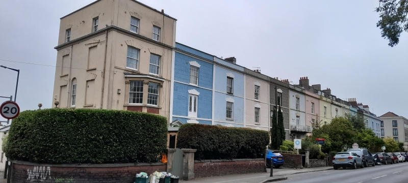
Includes: Wolseley House CORONATION ROAD. Terrace of 15 houses. 1822. Black render over brick with limestone dressings, brick party wall stacks and pantile valley roofs, mansards on Nos 166-170. Late Georgian style. Each of 3 storeys and basement; 1-window range. Attic storey on No.156, dormers on Nos 166-170. Pilaster strips to the party walls, first-floor plat and sill bands, deep cornice and parapet. Left-hand doorcases have open pediments on attached columns with pedestals and fanlights; No.170 is set back on the right with a 2-storey entrance block, and No.156 has a side entrance porch of rusticated ashlar and a Doric doorcase, and a late C19 brick 2-storey canted bay to the front. 7 stepped voussoirs with dropped keys to 8/8-pane sashes with fine bars. Nos 166 & 167 have first-floor balconies and French windows. INTERIOR: dogleg stairs from entrance halls, semicircular rear stair windows to the half-landings; flat, moulded cornices and ceiling roses in front and back ground-floor rooms, and fielded shutters. SUBSIDIARY FEATURES: some attached front garden walls with Pennant saddleback copings and octagonal piers. The first terrace built after the opening of the New Cut, and illustrated on Ashmead's 1828 Map of Bristol. (Bristol As It Was: Bristol's Suburbs Long Ago: Bristol: 443).
Listing NGR: ST5774372046
External links are from the relevant listing authority and, where applicable, Wikidata. Wikidata IDs may be related buildings as well as this specific building. If you want to add or update a link, you will need to do so by editing the Wikidata entry.


Other nearby listed buildings