Latitude: 51.4646 / 51°27'52"N
Longitude: -2.6113 / 2°36'40"W
OS Eastings: 357628
OS Northings: 174134
OS Grid: ST576741
Mapcode National: GBR C4F.FT
Mapcode Global: VH88M.PGC3
Plus Code: 9C3VF97Q+RF
Entry Name: Clifton Down Station Steam Tavern Public House and Attached Screen Walls
Listing Date: 30 December 1994
Grade: II
Source: Historic England
Source ID: 1202700
English Heritage Legacy ID: 380884
Also known as: Clifton Down Station Steam Tavern Public House And Attached Screen Walls
CFN
ID on this website: 101202700
Location: Clifton, Bristol, BS8
County: City of Bristol
Electoral Ward/Division: Clifton Down
Parish: Non Civil Parish
Built-Up Area: Bristol
Traditional County: Gloucestershire
Lieutenancy Area (Ceremonial County): Bristol
Church of England Parish: Clifton All Saints with St John
Church of England Diocese: Bristol
Tagged with: Railway station Pub Gothic Revival
BRISTOL
ST5774 WHITELADIES ROAD, Clifton 901-1/34/1131 (West side) Clifton Down Station, Steam Tavern Public House and attached screen walls
II
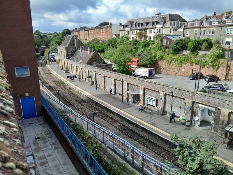
Railway station, now station and public house. Opened 1874, converted 1970s. Squared Pennant rubble with limestone dressings, lateral and ridge stacks and a tiled hipped roof. Single-depth plan. Tudor Gothic Revival style. 2 storeys; 3-window range, with single-storey side blocks either side. Central booking office has rock-faced quoins, impost band and sill band; corbel table below a weathered parapet; three 2-centre arches have splayed reveals and C20 glazing and door, and large second-floor cross windows with trefoil arches in flat heads. The roof has lead finials. End-gabled block each end have 5 single and paired flat-headed windows with glazing bars, the E block has a parapeted end section, the W block has a rounded corner beneath a moulded, corbelled corner. The rear elevation is articulated into rectangular recessed bays with corbel tables, with blocked openings to the backs of the station blocks. INTERIOR: converted to a public house. SUBSIDIARY FEATURES: screen wall, articulated into bays as the station buildings, extends from the station to the Whiteladies Road bridge (not included). Built as the terminus of the Clifton Extension Railway, it became a through station with the opening of the Clifton Down tunnel in 1885. Formerly with good glazed canopies on cast-iron posts, which extended on both sides supported by the screen walls (qv). (Oakely M: Bristol Suburban: Temple Meads, Local Stations etc: Bristol: 1990-: 42).
Listing NGR: ST5762874134
External links are from the relevant listing authority and, where applicable, Wikidata. Wikidata IDs may be related buildings as well as this specific building. If you want to add or update a link, you will need to do so by editing the Wikidata entry.


Other nearby listed buildings