Latitude: 51.2105 / 51°12'37"N
Longitude: -4.1143 / 4°6'51"W
OS Eastings: 252414
OS Northings: 147822
OS Grid: SS524478
Mapcode National: GBR KN.43JH
Mapcode Global: VH4M4.MTTX
Plus Code: 9C3Q6V6P+57
Entry Name: The Quay from Royal Britannia Hotel on West to Pier Hotel on East Including Old Quay Head
Listing Date: 12 March 1990
Grade: II*
Source: Historic England
Source ID: 1203010
English Heritage Legacy ID: 390271
ID on this website: 101203010
Location: Chambercombe, North Devon, EX34
County: Devon
District: North Devon
Civil Parish: Ilfracombe
Built-Up Area: Ilfracombe
Traditional County: Devon
Lieutenancy Area (Ceremonial County): Devon
Church of England Parish: Ilfracombe St Philip and St James
Church of England Diocese: Exeter
Tagged with: Wharf
ILFRACOMBE
SS5247 THE QUAY 853-1/7/130 The quay from Royal Britannia Hotel 12/03/90 on W to Pier Hotel on E inc Old Quay Head
GV II*
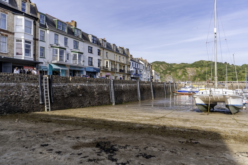
Quay, extending across the north side of the harbour, together with the pier projecting at right-angles from the east end, known as the Old Quay Head. C17 or earlier; the quay widened in mid C19, possibly more than once, the pier partly rebuilt and enlarged in 1760 and 1824-9. MATERIALS: built of local slatestone rubble with coping of dressed stone, probably limestone; east side of pier faced with large, squared blocks of limestone, these rising to form a parapet wall finished, at the northern end, with a round coping. Quay now has a mid or late C20 parapet wall of stone; the surface of the quay is covered with tarmac and there is a pavement along its north side. At the western end the quay wall curves round to form a slip running down in to the harbour. This may be a later addition, since there is a straight joint at the point where the curve begins. Some of the earlier coping stones appear to have been re-used at the top of the slip, but the surface of the latter is composed mostly of dressed blocks of hard slatestone polished by the sea. At the north end, the east wall of the pier is recessed to accommodate a steep flight of stone steps. At the south end, also on the east side, a long, shallow flight of stone steps projects, curving round towards the north-east. On top of the pier, close to these steps, the parapet wall has a semi-circular projection on the west side, this bearing a slate tablet (possibly re-set) inscribed: "This extensive Pier built some Ages since by the Munificence of the BOURCHIERS Barons of FITZWARINE EARLS OF BATHE and Vice ADMIRALS of this Place was in the Year 1760 partly rebuilt lengthened and enlarg'd by Sr. BOURCHIER WREY Bart. of the present Lord & inheritor of the Pier and Manor. A further enlargement of this Pier was commenced by Sr. BOURCHIER WREY Bart. in the year 1824 & completed in 1829 by Sir Bouchier Palk Wrey Bart. the present Lord of the Manor." The last Bourchier (Henry, 5th Earl of Bath) died without issue in 1654; Anne, third daughter of the 4th earl, married Sir Chichester Wrey, Bart. The borough manor of Ilfracombe was acquired by the Bourchiers in about 1435; John Bourchier, Lord Fitxwarren, was created Earl of Bath in 1536. The quay appears to have been widened by the Wreys after 1870, but comparison of maps of 1862 and 1869 suggests at least one earlier widening. Ilfracombe was a port of some significance by C13 and it is possible that the medieval quay survives, buried by later additions. Illustrations of the pier as remodelled by Sir Bourchier Wrey show it with a battlemented parapet and a small tower at the end of the quay. These features lasted until at least 1805, but had gone by 1829 when the pier acquired most of its present appearance. (Ilfracombe, A Pictorial Record, 1986: Horridge GK: Plates 1-6; Kelly's Directory of Devonshire: 1883-: 240; Visitations of the County of Devon: Vivian JL: 1895-: 107; Ilfracombe, 1984: Lamplugh L: 9; 'The Hundreds of Braunton, Shirwell and Fremington': Reichel OJ: Transactions of the Devonshire Association, Extra Volumes: 436).
Listing NGR: SS5241447822
External links are from the relevant listing authority and, where applicable, Wikidata. Wikidata IDs may be related buildings as well as this specific building. If you want to add or update a link, you will need to do so by editing the Wikidata entry.


Other nearby listed buildings