Approximate Location Map
Large Map »
Latitude: 51.2111 / 51°12'40"N
Longitude: -4.1129 / 4°6'46"W
OS Eastings: 252512
OS Northings: 147891
OS Grid: SS525478
Mapcode National: GBR KN.3XKV
Mapcode Global: VH4M4.NTJF
Plus Code: 9C3Q6V6P+FR
Entry Name: St Nicholas' Chapel and Lighthouse
Listing Date: 15 June 1951
Grade: I
Source: Historic England
Source ID: 1208792
English Heritage Legacy ID: 390232
Also known as: Ilfracombe lighthouse
ID on this website: 101208792
Location: St Nicholas's Chapel, Chambercombe, North Devon, EX34
County: Devon
District: North Devon
Civil Parish: Ilfracombe
Built-Up Area: Ilfracombe
Traditional County: Devon
Lieutenancy Area (Ceremonial County): Devon
Church of England Parish: Ilfracombe St Philip and St James
Church of England Diocese: Exeter
Tagged with: Lighthouse Chapel
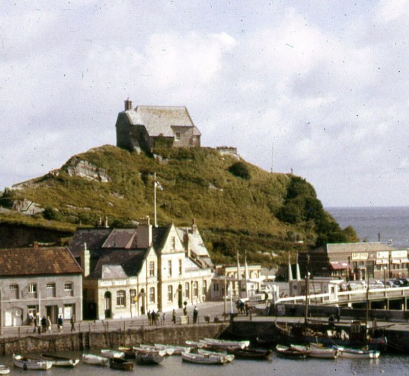
ILFRACOMBE
SS5247 LANTERN HILL
853-1/7/95 St Nicholas' Chapel and Lighthouse
15/06/51
GV I
Chapel (now disused) incorporating a lighthouse lantern,
situated on a high rock, known as Lantern Hill, between the
sea and harbour. Possibly C14 and known to be in existence by
early C15. By the time of Henry VIII used as a lighthouse but
present lantern C18/early C19.
Rubble, part rendered and slated roofs, that over western
chancel lower and crowned by lantern.
Bulging west end an early C20 reinforcement covering the
original wall behind with 2 lancet windows.
Rectangular plan approx. 31'6" x 13'3" internally; reverse
orientated with gabled rubble porch at east end, lit by
windows and having plank door, and lean-to porch on south
elevation with sash window to right.
North elevation has a sash and a casement window and roof
dormer. To right, the projecting base of a presumed turret
including the window sill. Octagonal lantern with ogee roof
surmounted by a copper fish-shaped weather vane with cut-out
letter "B" and date "1819".
INTERIOR not inspected but believed to retain C18 internal
fittings.
Date of closure for worship not known but seems to have been
used for various purposes over last 200 years; during the C19
it was used as a dwelling house, reading room and laundry.
This chapel is a prominent and important feature of the
harbour.
(National Monuments Record: Hussell AT: Measured drawing:
Sept.: 1943-).
Listing NGR: SS5251247890
External links are from the relevant listing authority and, where applicable, Wikidata. Wikidata IDs may be related buildings as well as this specific building. If you want to add or update a link, you will need to do so by editing the Wikidata entry.


Other nearby listed buildings
