Latitude: 53.6065 / 53°36'23"N
Longitude: -2.6656 / 2°39'56"W
OS Eastings: 356055
OS Northings: 412420
OS Grid: SD560124
Mapcode National: GBR 9VTQ.PX
Mapcode Global: WH97K.0MY1
Plus Code: 9C5VJ84M+HQ
Entry Name: Bogburn Hall
Listing Date: 17 April 1967
Last Amended: 21 February 1984
Grade: II
Source: Historic England
Source ID: 1204087
English Heritage Legacy ID: 357602
ID on this website: 101204087
Location: Coppull Moor, Chorley, Lancashire, PR7
County: Lancashire
District: Chorley
Civil Parish: Coppull
Built-Up Area: Coppull
Traditional County: Lancashire
Lieutenancy Area (Ceremonial County): Lancashire
Church of England Parish: Coppull St John
Church of England Diocese: Blackburn
Tagged with: House
SD 51 SE COPPULL BOGBURN LANE
8/85 Bogburn Hall
17.4.1967 (Formerly listed as Bogburn Hall
GV II Farmhouse)
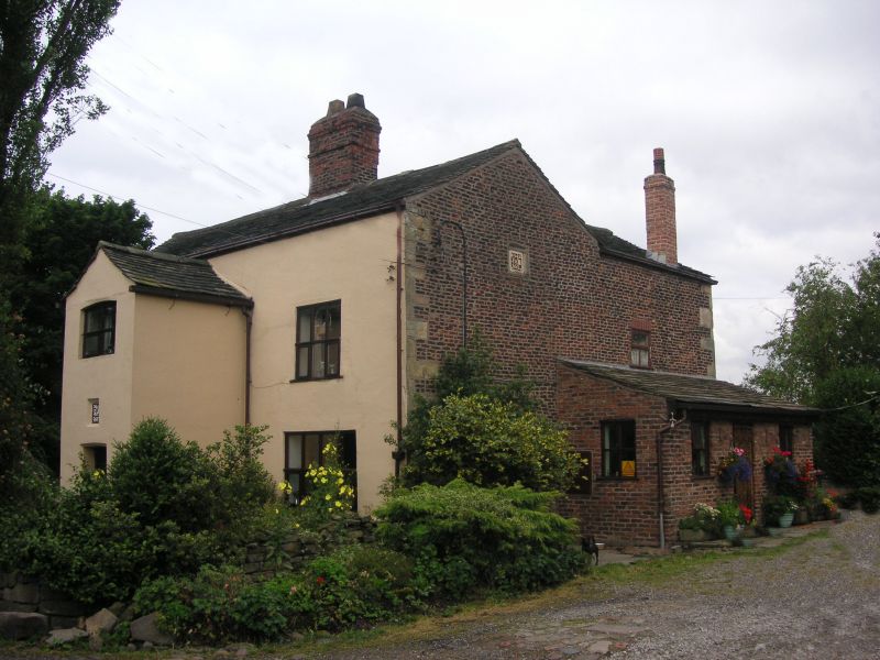
Farmhouse, dated 1663. Brick on stone plinth, with stone quoins,
scored render to facade and left return wall, stone slate roof (felted
at rear) with a chimney on the ridge. Two bay baffle-entry plan with
outshut to 1st bay and gabled 2½ storey extension to rear of 2nd bay.
Two storeys; central 2-storey gabled porch which has a chamfered and
slightly arched opening with stone jambs and lintel, and stone side
benches, and an inner studded plank door in wooden case with cyma-stopped
chamfer; above the entrance is a recessed square datestone lettered H
R.A
1663,
and at 1st floor a 2-light sliding sash window; otherwise, all 4 front
windows are altered (early C20 bays at ground floor). Right return wall
has at attic level a square datestone in chamfered stone frame, lettered
in relief H Various windows in rear wall include segmental-headed
:I:·:
1663
stairlight to 1st bay, a 2-light sliding sash to ground floor, and a fixed
attic window with glazing bars. Interior: many original features include
diamond-pattern stone flagged floor, ¼-round moulded beams, inglenook
fireplace with stone heck and very large bressummer, staircase with some
splat balusters, some internal timber framing, batten and board doors with
stop-chamfered cases, smoke hood in attic c. 4 metres square, and 4 roof
trusses with raking struts and collars; both sets of principals survive,
that for the original steeper roof (with housings for purlins) and that
which replaces it. History: home of Haydock family, used for Quaker
meetings in late Cl7. (H.C. Porteus History of Standish; plaque in
chancel of Church of St. John the Divine, q.v.).
Listing NGR: SD5605512420
External links are from the relevant listing authority and, where applicable, Wikidata. Wikidata IDs may be related buildings as well as this specific building. If you want to add or update a link, you will need to do so by editing the Wikidata entry.


Other nearby listed buildings