Latitude: 51.9991 / 51°59'56"N
Longitude: -0.9886 / 0°59'18"W
OS Eastings: 469532
OS Northings: 233888
OS Grid: SP695338
Mapcode National: GBR 9XQ.NVL
Mapcode Global: VHDT8.T07T
Plus Code: 9C3XX2X6+JH
Entry Name: Trolly Hall
Listing Date: 13 October 1952
Last Amended: 21 November 1994
Grade: II*
Source: Historic England
Source ID: 1204476
English Heritage Legacy ID: 377132
ID on this website: 101204476
Location: Buckingham, Buckinghamshire, MK18
County: Buckinghamshire
Civil Parish: Buckingham
Built-Up Area: Buckingham
Traditional County: Buckinghamshire
Lieutenancy Area (Ceremonial County): Buckinghamshire
Church of England Parish: Buckingham
Church of England Diocese: Oxford
Tagged with: House
BUCKINGHAM
SP6933 CASTLE STREET 879-1/6/31 (South side) 13/10/52 No.16 Trolly Hall (Formerly Listed as: CASTLE STREET (South side) No.16 Trolly Hill)
GV II*
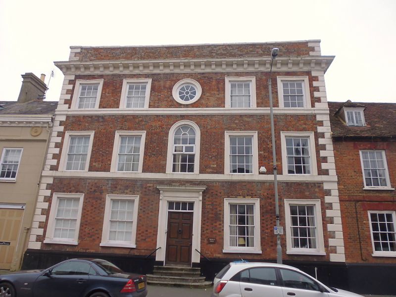
Large town house, now partly offices. Early C18, with C19 and C20 alterations. Red brick in Flemish bond with flared headers, stone dressings, all painted, hipped plain-tile roof and brick end stacks. Double-depth plan. 3-storey, 5-window range. Central, 6-panel door, approached by 3 stone steps with rounded ends. Door has overlight divided into 4 lights with shallow ogee-arched heads, moulded stone surround and cornice supported by console brackets either end. 12-pane sash windows to ground, first and 2nd floors, round arch-headed window to 1st floor centre and circular window to 2nd floor above, all with moulded stone surrounds. Rendered plinth with wave-moulded coping, rusticated quoins and sill bands, that to 1st hollow-chamfered to underside, that to 2nd with wave moulding to underside and extra upper moulding. Deep bracketed stone cornice, and plain stone-coped parapet with rusticated quoins. Central projection to rear housing staircase, and 2-storey extension to rear left. INTERIOR: dogleg stair from ground floor to attic with turned balusters on bulbous feet, moulded handrail, square newels and close strings. Stone cellar. Some rooms with raised and fielded panelling. Replaces a house of 1670 destroyed in fire of 1725. (Richardson A E: The Smaller English House: 207; FIG 193).
Listing NGR: SP6953833888
External links are from the relevant listing authority and, where applicable, Wikidata. Wikidata IDs may be related buildings as well as this specific building. If you want to add or update a link, you will need to do so by editing the Wikidata entry.


Other nearby listed buildings