Approximate Location Map
Large Map »
Latitude: 51.9993 / 51°59'57"N
Longitude: -0.9884 / 0°59'18"W
OS Eastings: 469542
OS Northings: 233914
OS Grid: SP695339
Mapcode National: GBR 9XQ.NWM
Mapcode Global: VHDT8.T09N
Plus Code: 9C3XX2X6+PJ
Entry Name: 18 and 19, Castle Street
Listing Date: 21 November 1994
Grade: II
Source: Historic England
Source ID: 1281180
English Heritage Legacy ID: 377134
ID on this website: 101281180
Location: Buckingham, Buckinghamshire, MK18
County: Buckinghamshire
Civil Parish: Buckingham
Built-Up Area: Buckingham
Traditional County: Buckinghamshire
Lieutenancy Area (Ceremonial County): Buckinghamshire
Church of England Parish: Buckingham
Church of England Diocese: Oxford
Tagged with: Building
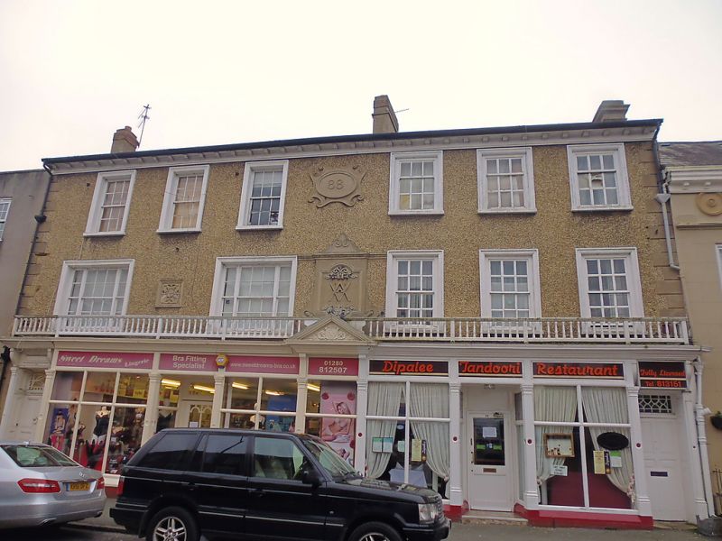
BUCKINGHAM
SP6933 CASTLE STREET
879-1/6/33 (South side)
Nos.18 AND 19
GV II
Pair of houses in one building, now flats, shop and
restaurant. Late C18, altered 1889 when made into store, and
C20 when re-divided. Pebbledashed render over brick with
cemented dressings, slate roof and rendered ridge and end
stacks. Double-depth plan. 3-storey, 6-window range.
6-panel doors to far left and far right either end of 1889
shop front. Both have rectangular fanlights of differing
patterns, panelled reveals, and pilastered wood surrounds.
Continuous moulded cornice extends over doors and shop front
with pediment to central bay and timber balcony with turned
balusters. Pair of tripartite sash windows to 1st floor right
of centre and 2nd floor with moulded wood surrounds. Cemented
decoration of rusticated quoins above ground floor level,
square panel between tripartite sashes, large central panel
framing monogram with initials V A and cartouche above bearing
date 1889. Deep, bracketed wood eaves cornice.
Formerly Vyles, 'the nearest thing to a department store the
town has ever had'.
(Birch C: Buckingham - The Town and District In Camera: 1986-:
24).
Listing NGR: SP6954633909
External links are from the relevant listing authority and, where applicable, Wikidata. Wikidata IDs may be related buildings as well as this specific building. If you want to add or update a link, you will need to do so by editing the Wikidata entry.


Other nearby listed buildings
