Approximate Location Map
Large Map »
Latitude: 50.8436 / 50°50'36"N
Longitude: -0.2189 / 0°13'7"W
OS Eastings: 525497
OS Northings: 106403
OS Grid: TQ254064
Mapcode National: GBR JNT.5GG
Mapcode Global: FRA B6FV.VZV
Plus Code: 9C2XRQVJ+CF
Entry Name: Kemps, with Wall Adjoining to North East
Listing Date: 22 September 1971
Last Amended: 2 November 1992
Grade: II
Source: Historic England
Source ID: 1205680
English Heritage Legacy ID: 365546
ID on this website: 101205680
Location: Portslade-by-Sea, Brighton and Hove, West Sussex, BN41
County: The City of Brighton and Hove
Electoral Ward/Division: South Portslade
Parish: Non Civil Parish
Built-Up Area: Portslade-by-Sea
Traditional County: Sussex
Lieutenancy Area (Ceremonial County): East Sussex
Church of England Parish: Portslade St Nicolas and St Andrew and Mile Oak The Good Shepherd
Church of England Diocese: Chichester
Tagged with: Architectural structure
HOVE
TQ2506SW HIGH STREET, Portslade
579-1/9/165 (North side)
22/09/71 Nos.69 AND 71
Kemps, with wall adjoining to NE
(Formerly Listed as:
PORTSLADE
HIGH STREET, Old Portslade
Nos.69 AND 71)
GV II
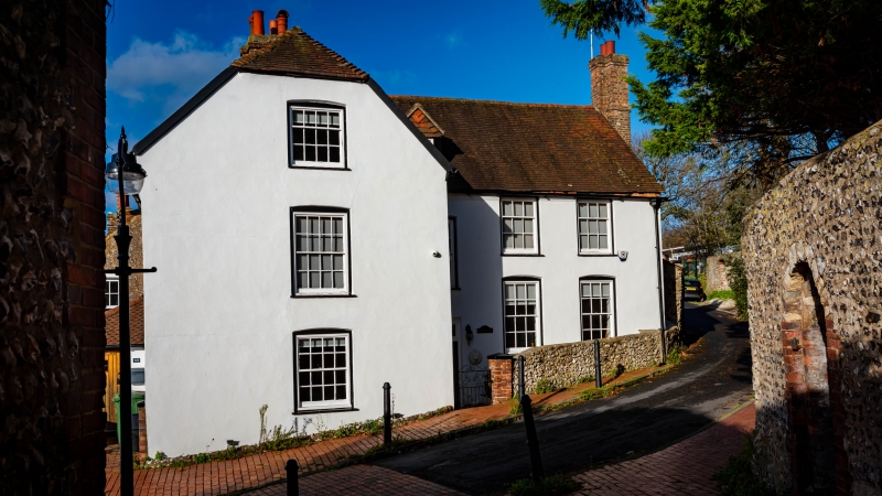
Farmhouse now divided into two dwellings. Believed to be C16,
enlarged early C17, subsequent alterations including
refenestration in mid C19. Said to be timber-framed, render
grooved as ashlar, clay tiled roofs, half-hipped gable ends
with catslide over outshot on west front, large brick stack
with narrow recessed panels at junction with wing, possibly
C16, external stack east gable end with tall rendered chimney,
possibly with remains of bread oven adjoining in south-east
corner.
T-plan, main range lying north-south set gable end onto road,
entrance to No.71 at junction with east wing, wall returned at
north-east corner, outshot on west front with porch in angle
(entrance to No.69).
2 storeys plus attic; south front: gable end with fixed upper
light 12-pane sash window, cambered heads to 16-pane sash
windows below, similar fenestration on left return, east wing
set back to right with 16-pane sash window with cambered head
lighting the stairs that rise behind the entrance, two 12-pane
sash windows right, 16-pane sashes with cambered heads below,
6-panel door. Later alterations on north facade, skylights
inserted in roof space.
Interiors not seen: said to contain features of interest.
No.69 is said to have a newel stair with wooden treads rising
beside the chimney stack and a C13 tomb slab laid in the
kitchen floor. Wall returned from NE corner for about 15m,
random rubble with tiled saddleback coping, entrance broken
through the wall and boarded up.
(Victoria County History: The Rape of Lewes: 1940-: 282).
Listing NGR: TQ2548206393
External links are from the relevant listing authority and, where applicable, Wikidata. Wikidata IDs may be related buildings as well as this specific building. If you want to add or update a link, you will need to do so by editing the Wikidata entry.


Other nearby listed buildings
