Latitude: 52.9241 / 52°55'26"N
Longitude: -2.4253 / 2°25'30"W
OS Eastings: 371506
OS Northings: 336380
OS Grid: SJ715363
Mapcode National: GBR 7X.MZ9B
Mapcode Global: WH9BY.QR9P
Plus Code: 9C4VWHFF+JV
Entry Name: Oakley Folly
Listing Date: 17 November 1966
Grade: II
Source: Historic England
Source ID: 1205874
English Heritage Legacy ID: 362623
ID on this website: 101205874
Location: Newcastle-under-Lyme, Staffordshire, TF9
County: Staffordshire
District: Newcastle-under-Lyme
Civil Parish: Loggerheads
Traditional County: Staffordshire
Lieutenancy Area (Ceremonial County): Staffordshire
Church of England Parish: Hales St Mary
Church of England Diocese: Lichfield
Tagged with: Architectural structure
SJ 73 NW LOGGERHEADS C.P B5415 (off east side)
Tyrley
8/141 Oakley Folly
17/11/66
II
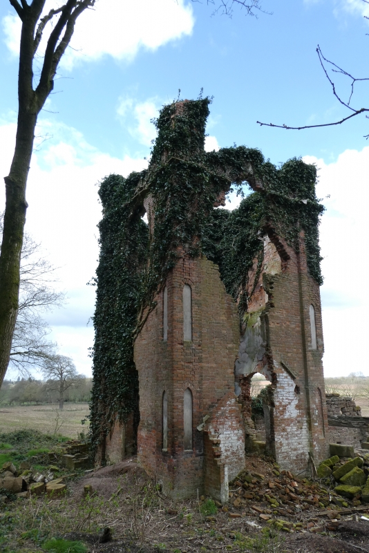
Folly, now ruinous. Probably late C18. Red brick and coursed sandstone
rubble with ashlar dressings, plain tiled roofs. Built in the form of a
late C18 church, consisting of nave and tower. Tower: brick in 3 short
stages with moulded stone cornice and brick parapet, carried up as chimney
stack in south-east corner; brick corner pilasters with blind lancet
decoration, one to each stage; broad lancet windows to each face, now
much mutilated; against the east face are the foundations and the outline
of the roof pitch of a former brick lean-to. "Nave": coursed sandstone.
Rectangular plan. 2 levels; wide round-arched entrances on long sides
with raised keystones and imposts; beam ends supporting former first
floor are visible through put-log holes. Interior: staircase in north-
east corner of tower leads down to basement and up to second and third
stages; access to former first floor of "nave" through doorway in north
face of tower. Remains of fireplaces in south-east corner of tower,
that to third stage with classical pediment. The "nave" was originally
used as a field barn; later, at the end of C19, the tower was adopted
by Sir Philip Chetwode as a place from which to view his racing horses.
The folly was subsequently converted to domestic accommodation, but is
said to have been struck by lightning and is in poor condition due to
neglect at time of re-survey (1984).
Listing NGR: SJ7150636380
External links are from the relevant listing authority and, where applicable, Wikidata. Wikidata IDs may be related buildings as well as this specific building. If you want to add or update a link, you will need to do so by editing the Wikidata entry.


Other nearby listed buildings