Latitude: 50.263 / 50°15'46"N
Longitude: -5.0494 / 5°2'57"W
OS Eastings: 182759
OS Northings: 44782
OS Grid: SW827447
Mapcode National: GBR ZF.XGV3
Mapcode Global: FRA 089B.JNK
Plus Code: 9C2P7X72+56
Entry Name: Wear House
Listing Date: 30 July 1993
Grade: II
Source: Historic England
Source ID: 1205912
English Heritage Legacy ID: 377528
ID on this website: 101205912
Location: Truro, Cornwall, TR1
County: Cornwall
Civil Parish: Truro
Built-Up Area: Truro
Traditional County: Cornwall
Lieutenancy Area (Ceremonial County): Cornwall
Church of England Parish: St Mary Truro
Church of England Diocese: Truro
Tagged with: House
TRURO
880-1/7/215 PRINCE'S STREET
30-JUL-93 TRURO
(South side)
8
Wear House
II
Also Known As: 10, PRINCE'S STREET, TRURO
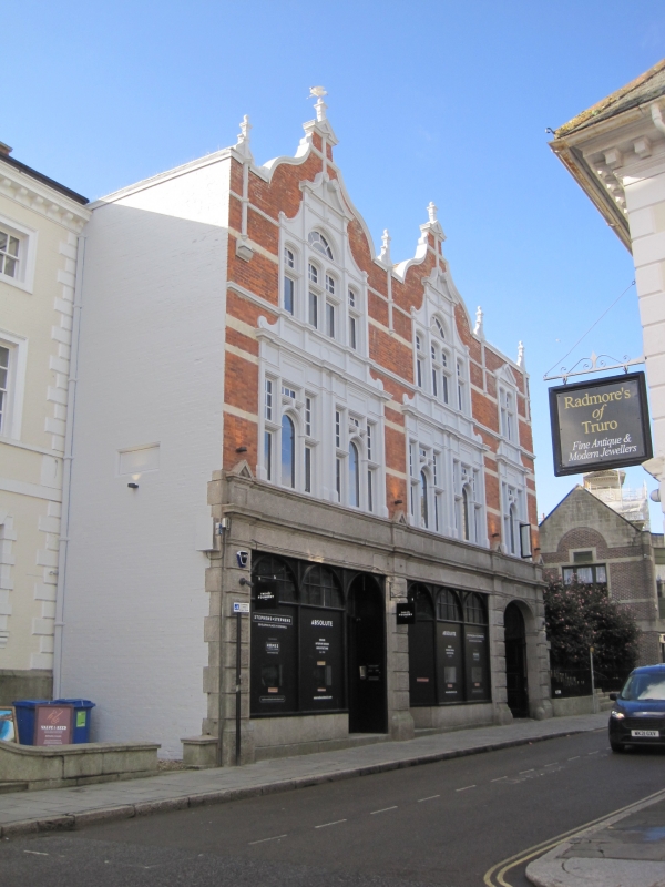
Originally two shops with offices over, but now one shop. This building was constructed in around 1889 for a Mr Polkinhorn, with James Clemens being responsible for the masonry, and William J. Tippet for the carpentry to a design prepared by Silvanus Trevail.
Brick with granite and freestone bands and dressings, and stucco details; dry Delabole slate roofs with gables onto the street; cast-iron ogee gutters. Rectangular plan. Jacobethan style. 3 storeys; 3 bays. Street front has pair of shopfronts (centre and left) and an elliptical-arched carriage opening on the right, articulated by rock-faced granite pilasters with their entablature breaking forward from the full-width moulded entablature with a 2-tier fascia. Shop fronts have round-headed lights. Large double doors of carriage doorway have raised and fielded panels. Stone-mullioned and transomed windows. First floor of 2:2:1 bays with tripartite Ipswich window with stepped entablature to each bay. Second floor has 2 wide bays surmounted by shaped gables, with triangular pediments and finials to left and plain parapet to right; finials between the bays; 4-light windows under gables have central fanlights surmounted by scrolled pediments; 2-light window over carriageway has triangular pediments.
INTERIOR: shop altered C20, otherwise not inspected. Included for group value.
Shown as No.10 Prince's Street on Ordnance Survey map.
Sources:- West Briton, 11th October 1888.
Listing NGR: SW8275644782
External links are from the relevant listing authority and, where applicable, Wikidata. Wikidata IDs may be related buildings as well as this specific building. If you want to add or update a link, you will need to do so by editing the Wikidata entry.


Other nearby listed buildings