Approximate Location Map
Large Map »
Latitude: 53.2586 / 53°15'30"N
Longitude: -2.1062 / 2°6'22"W
OS Eastings: 393014
OS Northings: 373512
OS Grid: SJ930735
Mapcode National: GBR FZQR.TL
Mapcode Global: WHBBP.MC88
Plus Code: 9C5V7V5V+CG
Entry Name: Farm Buildings at Lark Hall Yard
Listing Date: 17 March 1977
Last Amended: 28 October 1994
Grade: II
Source: Historic England
Source ID: 1206906
English Heritage Legacy ID: 390971
ID on this website: 101206906
Location: Higherfence, Cheshire East, Cheshire, SK10
County: Cheshire East
Civil Parish: Macclesfield
Built-Up Area: Macclesfield
Traditional County: Cheshire
Lieutenancy Area (Ceremonial County): Cheshire
Church of England Parish: Macclesfield St Paul
Church of England Diocese: Chester
Tagged with: Agricultural structure
MACCLESFIELD
SJ9373 COTTAGE LANE
886-1/7/71 (East side)
17/03/77 Farm buildings at Lark Hall Yard
(Formerly Listed as:
LARK HALL YARD, COTTAGE LANE
Nos.1-7 (Odd))
GV II
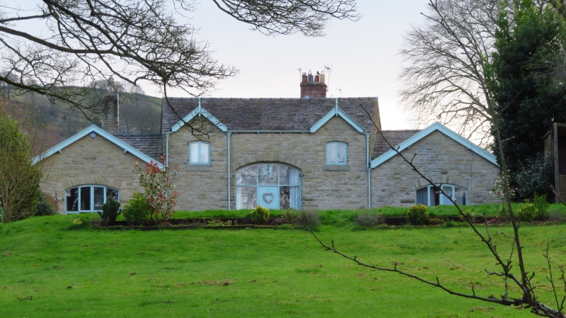
Group of farm buildings forming a courtyard, including
threshing barn and shelter sheds. Part dated 1874. Coursed and
squared rubble and brick with stone-flagged roofs. Barn forms
one side of courtyard, with open structure facing yard, the
roof carried on brick piers. Central entrance with low brick
walls to storage bays each side. Rear elevation has central
double doors in segmental archway dated 1874 with initials SA
in the keystone. Smaller segmental arched openings to upper
loft with plank shutters set beneath gabled dormers with
finials to bargeboards. Flanking shelter sheds form
right-angled returns of courtyard, with segmentally-arched
openings (blocked in western unit) in rear elevation forming
symmetrical composition with barn. Some alteration to openings
on courtyard side, but original stabling(?) survives in
right-hand (eastern) range: 2 doorways and 3 windows. Open
shelter shed alongside, the roof carried on cast-iron column.
Similar structure to left hand range, with some open shelter
bays as well as enclosed animal accommodation. Probably built
or rebuilt as a single planned development.
Listing NGR: SJ9301473512
External links are from the relevant listing authority and, where applicable, Wikidata. Wikidata IDs may be related buildings as well as this specific building. If you want to add or update a link, you will need to do so by editing the Wikidata entry.


Other nearby listed buildings
