Approximate Location Map
Large Map »
Latitude: 53.1456 / 53°8'44"N
Longitude: -1.198 / 1°11'52"W
OS Eastings: 453739
OS Northings: 361244
OS Grid: SK537612
Mapcode National: GBR 8F5.XL5
Mapcode Global: WHDFZ.K6RB
Plus Code: 9C5W4RW2+7R
Entry Name: 36, 38 and 38A, West Gate
Listing Date: 17 March 1978
Grade: II
Source: Historic England
Source ID: 1207193
English Heritage Legacy ID: 391780
ID on this website: 101207193
Location: Mansfield, Nottinghamshire, NG18
County: Nottinghamshire
District: Mansfield
Electoral Ward/Division: Woodlands
Parish: Non Civil Parish
Built-Up Area: Mansfield
Traditional County: Nottinghamshire
Lieutenancy Area (Ceremonial County): Nottinghamshire
Church of England Parish: Mansfield St John with St Mary
Church of England Diocese: Southwell and Nottingham
Tagged with: Building
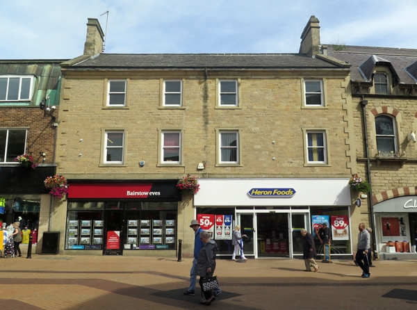
MANSFIELD
SK5361 WEST GATE
924-1/5/124 (North East side)
17/03/78 Nos.36, 38 AND 38A
GV II
2 houses, now 2 shops. Early C19, restored and ground floor
rebuilt c1990. Coursed squared stone with ashlar ground floor
and dressings, and slate roof with coped gables and 2 coped
ashlar gable stacks. Quoins and moulded eaves cornice. 3
storeys; 4-window range of plain sashes, and above, 4 smaller
plain sashes, the lower windows are renewed and have renewed
projecting stone surrounds. Ground floor has 2 glazed shop
fronts with plastic fascias.
Listing NGR: SK5373961244
External links are from the relevant listing authority and, where applicable, Wikidata. Wikidata IDs may be related buildings as well as this specific building. If you want to add or update a link, you will need to do so by editing the Wikidata entry.


Other nearby listed buildings
