Approximate Location Map
Large Map »
Latitude: 51.5285 / 51°31'42"N
Longitude: -0.1154 / 0°6'55"W
OS Eastings: 530831
OS Northings: 182745
OS Grid: TQ308827
Mapcode National: GBR L6.88
Mapcode Global: VHGQS.YVC4
Plus Code: 9C3XGVHM+9V
Entry Name: Police Station
Listing Date: 30 September 1994
Grade: II
Source: Historic England
Source ID: 1207691
English Heritage Legacy ID: 369058
ID on this website: 101207691
Location: Finsbury, Islington, London, WC1X
County: London
District: Islington
Electoral Ward/Division: Clerkenwell
Parish: Non Civil Parish
Built-Up Area: Islington
Traditional County: Middlesex
Lieutenancy Area (Ceremonial County): Greater London
Church of England Parish: Clerkenwell Holy Redeemer
Church of England Diocese: London
Tagged with: Police station
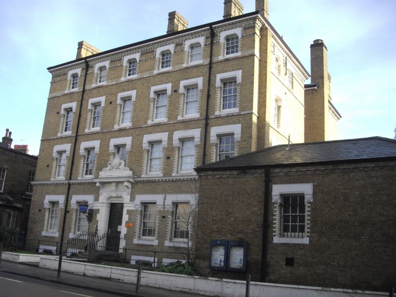
ISLINGTON
TQ3082NE KING'S CROSS ROAD
635-1/67/543 (East side)
No.76
Police Station
GV II
Police Station. 1869-1870 by Thomas Charles Sorby, Surveyor to
the Metropolitan Police. Stock bricks with Portland and
Tilbury stone dressings to front elevation; projecting eaves
to roof, material obscured; prominent brick stacks to bearing
walls. Italianate style. Four storeys with basement and
one-storey Welsh-slate hipped roof block breaking forward
along the front right facade; 6-window range. Assymetrical
double-fronted with irregular end bays breaking forward and
4-window range centrepiece in recess. Steps rise to slightly
off-centre single-bay porch entrance with stone dressings, and
bracketed cornice surmounted by elaborate stone sculpture with
heraldic supporters, possibly of a later date. 6/6 sashes with
brick and stone surrounds throughout, windows becoming shorter
as they rise. Ornament in loose, almost brutal manner; stone
and brick sill bands to upper floors. Lavish brick cornice
beneath eaves. Built as Clerkenwell Police Station to replace
an earlier station of 1842 part of which appears to remain
attached to the Magistrates Court (q. v.).
(Historians File, English Heritage, London Division: 1990-).
Listing NGR: TQ3083182745
External links are from the relevant listing authority and, where applicable, Wikidata. Wikidata IDs may be related buildings as well as this specific building. If you want to add or update a link, you will need to do so by editing the Wikidata entry.


Other nearby listed buildings
