Approximate Location Map
Large Map »
Latitude: 51.4484 / 51°26'54"N
Longitude: -2.623 / 2°37'22"W
OS Eastings: 356802
OS Northings: 172342
OS Grid: ST568723
Mapcode National: GBR C1M.TM
Mapcode Global: VH88M.HV5J
Plus Code: 9C3VC9XG+9R
Entry Name: Brunel's south entrance lock and swing bridge
Listing Date: 18 February 1972
Last Amended: 16 June 2023
Grade: II*
Source: Historic England
Source ID: 1207824
English Heritage Legacy ID: 379469
ID on this website: 101207824
Location: Hotwells, Bristol, BS1
County: City of Bristol
Electoral Ward/Division: Hotwells and Harbourside
Parish: Non Civil Parish
Built-Up Area: Bristol
Traditional County: Gloucestershire
Lieutenancy Area (Ceremonial County): Bristol
Church of England Parish: Clifton Holy Trinity with St Andrew the Less and St Peter
Church of England Diocese: Bristol
Tagged with: Architectural structure Lock
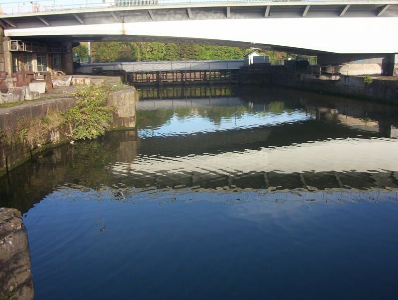
A lock of 1844-1849 by IK Brunel (gates removed) and later swing bridge (now fixed). A concrete wall and sluices were inserted in the chamber in around 1890.
Lock and quay walls of 1844-1849 by IK Brunel and swing bridge of 1875-1876 to an earlier design of IK Brunel.
MATERIALS: the lock is constructed of pennant rubble and ashlar. The bridge is steel.
DESCRIPTION: an inverted elliptical-arched basin with a chamfered recess and a hinge in the south side for the single-leaf wrought-iron caisson gate which sealed the lock, and channels for the hand-operated chains which closed them. The lock is now sealed by a concrete wall with sluice gates. The bridge has tubular section long members, steel sides and timber-floored deck. It is fixed in its open position across the lock and the timber deck covering was replaced in the C21. To the Avon side of the bridge the lock has been shored up against the north chamber wall to provide a platform for boat repair and in 2023 is overgrown. To the basin side of the bridge there is a small dock set into the chamber wall and some coping stones have been replaced in concrete. A modern landing stage is attached alongside the wall. At the east entrance to the lock is a concrete jetty providing a footpath across the basin.
There is a former gas lamp standard beside the north end of the bridge with early C20 railings lining a raised section of surface that aligns with the open position of Brunel’s Swing Bridge alongside North Entrance Lock (Grade II*). The north end of this raised section of ground is faced in rubble stone. On the north side of the lock is a mid-C19 capstan marked: JD Green/ Bond Iron Founder.
Bristol’s Floating Harbour was designed and built in the early C19 to improve the function of the City’s port, and thereby its competitiveness in international trade. Access to the port was hampered by the extreme tidal range of the River Avon and by the mid- C18 Bristol was superseded by Liverpool as the principal English port linked to the transatlantic slave trade. In 1802, after much delay, the City’s merchants finally agreed a scheme to dam and bypass the river to create a floating harbour of around 70 acres that could function irrespective of the tide height. Ships would enter an open area of water called Cumberland Basin via one of two locks at Rownham and pass into the harbour via another lock at Hotwells. The River Avon was diverted into a ‘New Cut’ on a route to the south of the City with overfall dams to scour the harbour of silt.
William Jessop designed the scheme and was employed as Chief Engineer under the newly formed Bristol Dock Company (BDC); work started in 1803 following Parliamentary approval. The works were completed in 1809 and the basin and Floating Harbour are shown on the 1828 map by Plumley and Ashmead, along with bridges across both entrance locks. The Floating Harbour reputedly provided Bristol with the largest area of impounded water for shipping in the world and the two Entrance Locks into the Cumberland Basin from the River Avon were the largest structures of their kind yet built.
In 1832, BDC commissioned IK Brunel to design and install a new underfall dam to scour the basin as well as changes to the entrance locks, which had fallen into disrepair and could no longer accommodate the increasing size of steamships. Work started in 1842 to increase the length and width of the South Entrance Lock. Brunel’s pioneering wrought-iron caisson design, with single-leaf gates, maximised the operating length of the lock. Brunel intended to span the lock with a retractable rolling bridge, but instead in early 1849 he designed an innovative wrought-iron swing bridge, which his staff nick-named the ‘Swivel Bridge’ when it was completed in the autumn of 1850. The unusual ‘tubular’ top flanges on the side girders gave rise to the term ‘balloon topped bridge’ and were part of a new design type required to reach across the lock when closed. Brunel fixed wrought-iron tie-bars within the top flanges to counter deflections caused by the long length of the side girders. The lock opened in 1849 and is shown with bridges across both entrance locks on Ashmead’s Map of 1855. The capstan on the north side of Brunel's Lock can been attributed to JD Green who was superintendent of Works at the time Brunel worked on the lock. Its location suggests it was used to open the outer lock gate.
In 1863 the Bristol City Docks Engineer, Thomas Howard, designed and installed a three-quarter length ‘replica’ bridge over Jessop’s North Entrance Lock, which was eventually moved to Bathurst Basin following the creation of two new locks as part of Howard’s plans to improve the function of Cumberland Basin. Brunel’s Lock was recommended for closure to create a graving dock and Brunel’s original swing bridge was transferred to the newly built North Entrance Lock (Howard’s Lock) in 1873. The plan for a graving dock was subsequently dropped and in 1875-6 another replica swing bridge was installed for Brunel’s Lock. This replica bridge was constructed of steel and operated manually rather than hydraulically.
The new arrangement of locks and bridges is shown on the First Edition Ordnance Survey Map of 1886, by which time Brunel’s Lock had been taken out of use, the lock gates removed, and a dam and sluices installed. The 1870s hydraulic machinery of the bridge was renewed in 1901-1902 and manufactured by Sir W G Armstrong, Whitworth and Co Ltd of Newcastle upon Tyne. A dam with sluices was built to close it off to the River Avon in around 1890. The swing bridge was de-commissioned in 1968 following the construction of the Plimsoll Bridge as part of a new road system and is now fixed in its closed position across the lock with its ‘tail end’ removed. The deck was replaced in the C21.
Brunel’s south entrance lock and swing bridge is listed at Grade II* for the following principal reasons:
Architectural and Historic Interest:
* as an innovative and pioneering wrought-iron caisson lock design, with single-leaf gates to maximise the operating length of the lock;
* the work of I.K. Brunel as an engineer and as a designer is widely regarded as exemplary and often of national and international significance;
* non-railway designs associated with Brunel are rare and this is an unusual example of his lock design;
* the bridge is a later replica of an innovative Brunel design;
* Cumberland Basin itself is a rare example of a tidal basin design and a critical part of Bristol’s Floating Harbour, which in the early C19 was a bold constructional achievement.
Group Value:
* the bridge forms a distinct grouping with Brunel’s Swing Bridge alongside North Entrance Lock (Grade II*) and the Quay walls around Cumberland Basin (Grade II), with which it formerly shared raised road sections and fixtures that allowed for passage across the two locks and land between.
External links are from the relevant listing authority and, where applicable, Wikidata. Wikidata IDs may be related buildings as well as this specific building. If you want to add or update a link, you will need to do so by editing the Wikidata entry.


Other nearby listed buildings
