Approximate Location Map
Large Map »
Latitude: 51.5285 / 51°31'42"N
Longitude: -0.1094 / 0°6'33"W
OS Eastings: 531243
OS Northings: 182761
OS Grid: TQ312827
Mapcode National: GBR M6.L7
Mapcode Global: VHGQT.2V03
Plus Code: 9C3XGVHR+C6
Entry Name: Windmill base, New River Head
Listing Date: 29 December 1950
Last Amended: 26 September 2013
Grade: II
Source: Historic England
Source ID: 1208526
English Heritage Legacy ID: 369260
ID on this website: 101208526
Location: Finsbury, Islington, London, EC1R
County: London
District: Islington
Electoral Ward/Division: Clerkenwell
Parish: Non Civil Parish
Built-Up Area: Islington
Traditional County: Middlesex
Lieutenancy Area (Ceremonial County): Greater London
Church of England Parish: Clerkenwell St Mark
Church of England Diocese: London
Tagged with: Windmill
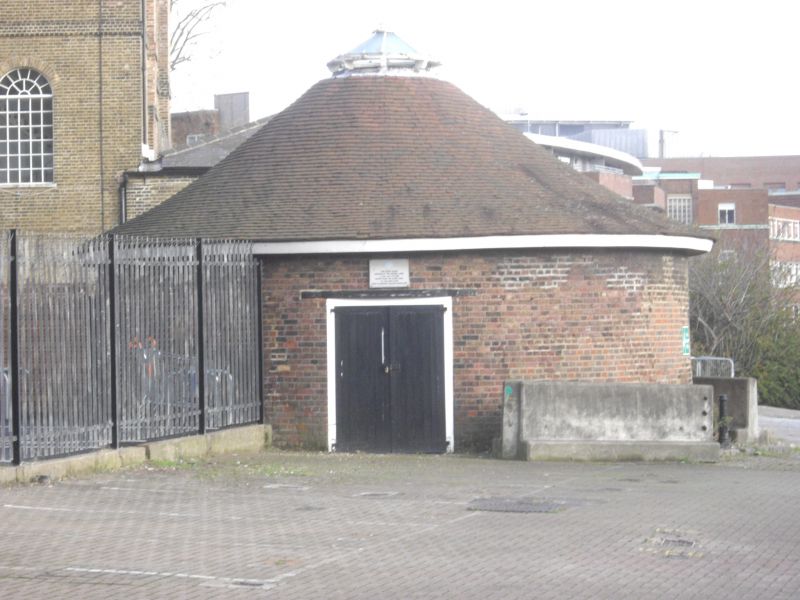
Base of windmill built 1707-8 to power water pumps. Tower demolished c1770 and in mid-C19, when the structure was converted to a store.
MATERIALS: red brick laid in English bond with numerous areas of C20 patching and repair where attached structures have been removed; clay tile roof.
DESCRIPTION: the windmill base is approximately 12m in diameter, with a blocked segmental-arched entrance on the north face. The later entrance to the south-west has a timber lintel and double doors with strap hinges. The conical roof has a small circular lantern to the apex. The interior has no surviving features of interest.
The New River Head takes its name from the terminus of the New River, the 40-mile channel cut in 1604-3 to supply the City of London with water from springs in Hertfordshire, a civil engineering achievement vital to the development of the metropolis. The scheme was directed by the City magnate, Hugh Myddelton, who became the first Governor of the New River Company (NRC) when it received its royal charter in 1619. From the high ground of rural Clerkenwell a network of wooden mains conveyed water to the cisterns of London. The site at first consisted of a reservoir - the Round Pond - and a single building known as the Water House containing the stop-cocks and accommodation for the site supervisor; over time these were supplemented by further buildings, ponds, cisterns and filter beds, covering seven acres.
In response to the demand for water supply to the expanding metropolis and strong competition from other companies, the NRC engaged George Sorocold, the first great English water-supply engineer, who in 1707-8 designed an experimental and expensive scheme for a windmill and an upper reservoir. The latter, known as the Upper Pond, stood some 350m to the north-west of the windmill in what is now Claremont Square, the higher ground providing a greater head of pressure to enable distribution to more distant areas in and around the West End. The windmill powered four pumps to force water uphill from the Round Pond to the Upper Pond. It consisted of a tapering round brick tower, then rare in England, with oval windows, an ogee cap, and six sails. At the base was an integral horse gin for use when there was little wind. The windmill did not work well, possibly due to its sheltered position, and was abandoned in 1720. Nor was the base large enough to serve well for the horse gin, and a new horse mill was built c1720 adjoining the defunct windmill on the south-east side, which supplied the Upper Pond until 1768 when the pumping engine house was built. In addition to the horse mill, the windmill had a small attached structure to the south-west side which appears on C18 maps. Around 1770 the windmill tower was reduced to two storeys and castellated, and by the mid-C19 it had been demolished down to the base and converted into a store. By 1874 the adjoining structures had been removed and replaced by a more substantial building on the south-east side, which was linked to the engine house's south-west boiler room. These structures were removed in the 1970s.
The windmill base, New River Head, is listed at Grade II for the following principal reasons:
* Historic interest and rarity: although representing only a small proportion of the original structure, it has considerable significance as evidence of the earliest phase of powered pumping on the New River Head site; there are no known surviving comparators within a waterworks nationally;
* Group value: with several listed buildings on the site built by the New River Company and its successor the Metropolitan Water Board from the C18 to the early C20; most notably the former engine house which continues the narrative of rapid technological advance and obsolescence in the water-supply industry; such a grouping is unique on a waterworks site.
External links are from the relevant listing authority and, where applicable, Wikidata. Wikidata IDs may be related buildings as well as this specific building. If you want to add or update a link, you will need to do so by editing the Wikidata entry.


Other nearby listed buildings
