Approximate Location Map
Large Map »
Latitude: 50.4887 / 50°29'19"N
Longitude: -3.5279 / 3°31'40"W
OS Eastings: 291709
OS Northings: 66551
OS Grid: SX917665
Mapcode National: GBR QV.VR5V
Mapcode Global: FRA 37HR.WYX
Plus Code: 9C2RFFQC+FR
Entry Name: 15, Fore Street
Listing Date: 20 November 1952
Last Amended: 3 May 1994
Grade: II
Source: Historic England
Source ID: 1208752
English Heritage Legacy ID: 390602
ID on this website: 101208752
Location: Combe Pafford, Torbay, Devon, TQ2
County: Torbay
Electoral Ward/Division: St Marychurch
Parish: Non Civil Parish
Built-Up Area: Torquay
Traditional County: Devon
Lieutenancy Area (Ceremonial County): Devon
Church of England Parish: St Marychurch St Mary the Virgin
Church of England Diocese: Exeter
Tagged with: Building Thatched farmhouse
TORQUAY
SX9166 FORE STREET, Barton
885-1/8/323 (East side)
20/11/52 No.15
(Formerly Listed as:
FORE STREET, Barton
No.15
Pavor Farmhouse)
GV II
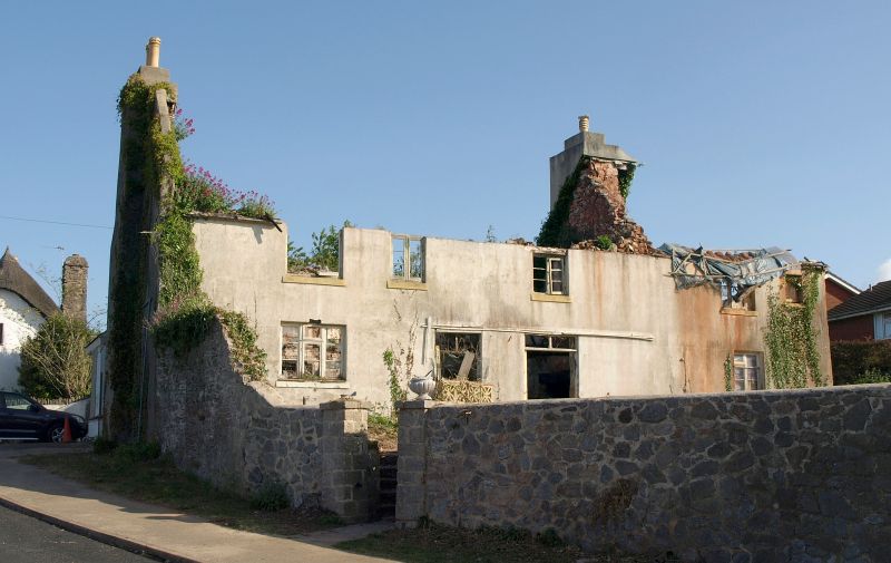
Farmhouse, now house. Late C17. Plastered mass walls; thatched
roof, replaced with corrugated asbestos to rear of ridge;
stacks with rendered shafts, left end stack projecting.
PLAN: Single-depth, 3-room plan, higher end to the right,
entrance faces stair. Rear left outshut.
EXTERIOR: 2 storeys. Asymmetrical 6-window front. Entrance to
left of centre with a fine moulded timber C17 doorframe, plank
door with strap hinges and probably original overlight.
Windows small 2-light casements with galzing bars. C20 glazed
door onto small section of C20 verandah across front.
INTERIOR: Centre room has a boxed-in cross beam. Right-hand
room (divided into 2) has a chamfered axial beam with runout
stops. First floor preserves a 2-panel door. Other features
likely to be concealed behind modern plaster. Roof: Feet of of
principal rafters visible upstairs are straight, apex of roof
not seen on survey.
A handsome late C17 farmhouse, now in a suburban setting.
Listing NGR: SX9170966551
External links are from the relevant listing authority and, where applicable, Wikidata. Wikidata IDs may be related buildings as well as this specific building. If you want to add or update a link, you will need to do so by editing the Wikidata entry.


Other nearby listed buildings
