Approximate Location Map
Large Map »
Latitude: 54.671 / 54°40'15"N
Longitude: -1.6694 / 1°40'9"W
OS Eastings: 421416
OS Northings: 530705
OS Grid: NZ214307
Mapcode National: GBR JGSF.CC
Mapcode Global: WHC52.BV8J
Plus Code: 9C6WM8CJ+96
Entry Name: Jock's Bridge
Listing Date: 6 May 1986
Last Amended: 2 June 2021
Grade: II
Source: Historic England
Source ID: 1208804
English Heritage Legacy ID: 385608
ID on this website: 101208804
Location: Bishop Auckland, County Durham, DL14
County: County Durham
Electoral Ward/Division: Bishop Auckland Town
Parish: Non Civil Parish
Traditional County: Durham
Lieutenancy Area (Ceremonial County): County Durham
Church of England Parish: Bishop Auckland
Church of England Diocese: Durham
Tagged with: Bridge Architectural structure
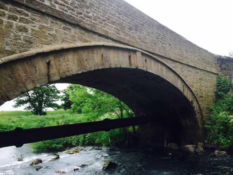
Road Bridge, C18; the east elevation was partially rebuilt in the early C19.
Road Bridge, C18; the east elevation was partially rebuilt in the early C19.
MATERIALS: coursed rubble with ashlar arch and dressings.
PLAN: a single-span bridge with abutments and short causeways to either end.
DESCRIPTION: the bridge carries a minor road from Bishop Auckland to Binchester across the River Gaunless immediately before the latter’s confluence with the River Wear. The single elliptical arch to both elevations has long, thin dressed voussoirs surmounted by a narrow archivolt, with raised keystones. The western (downstream) elevation has a ramped, humpbacked string course and parapet in keeping with the slight rise in road level towards the centre of the bridge; the string course and parapet on the eastern (upstream) elevation are both horizontal. Both parapets have V-shaped copings, but that on the west runs between square end pillars (with flat-topped caps) that rise as pilasters through the causeways; short wing walls beyond the pillars are lower and have rounded copings. The taller eastern parapet is also horizontal and has slightly smaller stonework. The keystone in the eastern elevation (only visible from within the Park) bears the inscription ‘SD | 1819’ (SD standing for Shute Dunelm, or Bishop Shute Barrington of Durham). Both bridge abutments are plain, and continue as short causeways at either end.
Auckland Castle Park originated as a deer park for the Prince Bishops of Durham, probably in the C11 or C12, associated with their residence at Auckland Castle. The park had a herd of wild cattle until the C17 and there are records of successive restocking with deer. The park fell into decline during the Interregnum at which time the trees were cut down, but it was restocked, and the fishponds renewed by Bishop Cosin during the period 1660 to 1671. In 1750 Bishop Butler extended the park to take in areas of woodland and began renewing the pale and planting, operations which were interrupted by his death in 1752. He was succeeded by Bishop Trevor, who continued with the improvements, spending more than £8,000 on the Castle and park during the period 1752 to 1771. Ewan Christian undertook a refurbishment of Castle and park during the 1880s for Bishop Lightfoot.
The overall form of the west elevation suggests that this bridge was constructed in the C18, probably that depicted on C18 maps including Richardson’s 1762 map of the Binchester Estate (DRO D/Bo G1/ (i)). On an estate map of about 1820 (DUL CCB MP/90b) the bridge is named as ‘Gaunless or Jock’s Row Bridge’, seemingly after a nearby row of houses, now demolished. The earliest Ordnance Survey map of 1861, and all later mapping, bear the name ‘Jock’s Bridge’. In 1819 the eastern elevation, which has a horizontal string course and parapet and smaller stonework, is thought to have been partially rebuilt for Bishop Shute Barrington as part of a scheme to integrate it into the wider parkland landscape; its east parapet accordingly forms part of the Auckland Castle Park boundary wall.
Jock's bridge, of C18 date, partially rebuilt in the early C19, is listed at Grade II for the following principal reasons:
Architectural interest:
* an attractive, well-detailed and intact elliptical-arched structure, of two early phases;
* its early C19 modification, intended to integrate it into the wider parkland landscape, contributes to its overall interest.
Historic interest:
* for its close historic association with Auckland Castle Park created for the Prince Bishops of Durham as a hunting estate.
Group value:
* it retains its historic relationship with the listed Auckland Castle and the registered Auckland Castle Park, and benefits from a spatial group value with numerous other listed buildings.
External links are from the relevant listing authority and, where applicable, Wikidata. Wikidata IDs may be related buildings as well as this specific building. If you want to add or update a link, you will need to do so by editing the Wikidata entry.


Other nearby listed buildings
