Approximate Location Map
Large Map »
Latitude: 51.018 / 51°1'4"N
Longitude: -4.207 / 4°12'25"W
OS Eastings: 245293
OS Northings: 126610
OS Grid: SS452266
Mapcode National: GBR KJ.J41Z
Mapcode Global: FRA 262F.8TS
Plus Code: 9C3Q2Q9V+65
Entry Name: 69, High Street
Listing Date: 19 March 1973
Grade: II
Source: Historic England
Source ID: 1208957
English Heritage Legacy ID: 375840
ID on this website: 101208957
Location: Bideford, Torridge, Devon, EX39
County: Devon
District: Torridge
Civil Parish: Bideford
Built-Up Area: Bideford
Traditional County: Devon
Lieutenancy Area (Ceremonial County): Devon
Church of England Parish: Bideford St Mary
Church of England Diocese: Exeter
Tagged with: Building
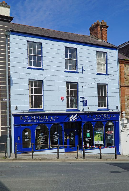
BIDEFORD
SS4526 HIGH STREET
842-1/5/129 (North side)
19/03/73 No.69
GV II
House with shop. Early C19. Solid rendered front with
rusticated render in upper storeys. Slate roof. Red-brick
chimney on each gable-end, that to right rebuilt. 3 storeys;
3-window range. Late C20 wooden shop front in ground storey.
6-paned sashes with chanelled voussoirs above. INTERIOR not
inspected.
Listing NGR: SS4529026622
External links are from the relevant listing authority and, where applicable, Wikidata. Wikidata IDs may be related buildings as well as this specific building. If you want to add or update a link, you will need to do so by editing the Wikidata entry.


Other nearby listed buildings
