Latitude: 53.4652 / 53°27'54"N
Longitude: -2.236 / 2°14'9"W
OS Eastings: 384431
OS Northings: 396525
OS Grid: SJ844965
Mapcode National: GBR DLN.JT
Mapcode Global: WHB9N.M5G9
Plus Code: 9C5VFQ87+3J
Entry Name: Pharmacy Department, Department of Adult Education, University of Manchester
Listing Date: 3 October 1974
Grade: II
Source: Historic England
Source ID: 1209002
English Heritage Legacy ID: 388035
ID on this website: 101209002
Location: University, Manchester, Greater Manchester, M15
County: Manchester
Electoral Ward/Division: Hulme
Parish: Non Civil Parish
Built-Up Area: Manchester
Traditional County: Lancashire
Lieutenancy Area (Ceremonial County): Greater Manchester
Church of England Parish: Hulme The Ascension
Church of England Diocese: Manchester
Tagged with: University building
This list entry was subject to a Minor Amendment on 26 March 2026 to amend the name, address and description due to a change in building use, reformat the text to current standards.
SJ8496
698-1/21/592
MANCHESTER
HIGHER CAMBRIDGE STREET
Coupland Building Three
The Old Medical School
(Formerly listed as No.3, Pharmacy Department, Department of Adult Education, University of Manchester, COUPLAND STREET, Chorlton-On-Medlock)
03/10/74
GV
II
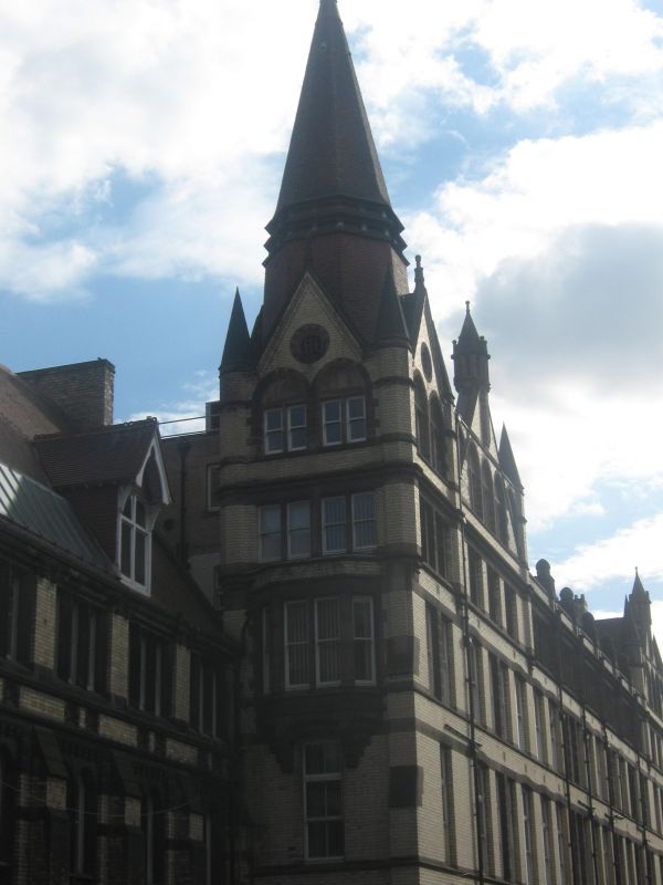
Former medical school, pharmacy department (etc) of University of Manchester at time of listing. 1874, by Alfred Waterhouse. Pale yellow brick with sandstone dressings, red tiled roofs. Irregular L-shaped plan formed by main range parallel to street, with set-back continuation at left end and rear wing to this. Four and two storeys.
The 4-storey main range, nine wide bays, the first (incorporating the entrance) treated as a corner tower, the second and ninth wider than the others and gabled, all these with corner pinnacles and the corner tower with a slated spirelet, has stone sill-bands and head-bands, cusped stone niches between the bays at top floor, and a moulded cornice and parapet. The corner tower has (inter alia) a large two-centred moulded entrance arch in each side at ground floor and a first floor oriel in the left side; otherwise, the ground, first and second floors have large sashed windows (variously one-, two- and three-lights), the third floor has stone mullioned four-light sashed windows, and the gables have three bay arcades of arched windows. The continuation to the left, two unequal storeys and seven narrow bays, has a tall ground floor with buttresses, tall cross-windows with arched lights, and corbel tables; three-light mullioned windows at first floor; gabled dormers over the second and sixth bays and a continous skylight between these; and a fleche on the ridge. Rear wing in similar style, irregular, with steeply-pitched roofs, dormers, etc.
Interior not inspected.
Listing NGR: SJ8443196525
External links are from the relevant listing authority and, where applicable, Wikidata. Wikidata IDs may be related buildings as well as this specific building. If you want to add or update a link, you will need to do so by editing the Wikidata entry.


Other nearby listed buildings