Approximate Location Map
Large Map »
Latitude: 54.657 / 54°39'25"N
Longitude: -1.685 / 1°41'5"W
OS Eastings: 420422
OS Northings: 529151
OS Grid: NZ204291
Mapcode National: GBR JGPL.0C
Mapcode Global: WHC58.26XP
Plus Code: 9C6WM848+R2
Entry Name: Road Bridge over railway
Listing Date: 23 May 1994
Last Amended: 5 August 2022
Grade: II
Source: Historic England
Source ID: 1209680
English Heritage Legacy ID: 385649
ID on this website: 101209680
Location: Bishop Auckland, County Durham, DL14
County: County Durham
Civil Parish: Bishop Auckland
Built-Up Area: Bishop Auckland
Traditional County: Durham
Lieutenancy Area (Ceremonial County): County Durham
Church of England Parish: Bishop Auckland
Church of England Diocese: Durham
Tagged with: Road bridge
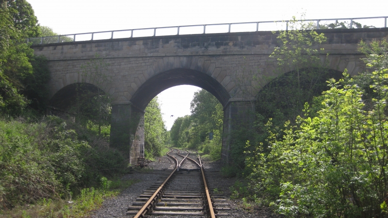
Railway overbridge, 1842-1843
Railway overbridge, 1842-1843
MATERIALS: Sandstone ashlar abutments, piers, arch barrels and parapets; spandrels of squared sandstone blocks laid in horizontal courses.
PLAN: skew arched bridge, between abutments that rise out of the railway cutting’s sides, and crosses the railway at an angle.
DESCRIPTION: this arch bridge comprises three segmental arches. The voussoirs in the arch rings rise from skewback stones above rectangular impost bands, and are stepped to key into the spandrels and help counteract the stresses inherent in a skew bridge. The voussoirs and intrados of each arch are laid according to the helicoidal method where the bedding joints between the stones are at right angles to the bridge elevations rather than to the faces of the abutments. The parapets, which are three ashlar courses high, are distinguished from the spandrels by a horizontal string course at the level of the road deck and surmounted by flat coping stones which, on the elevations of the bridge only, rise from a concave moulding to oversail the parapet walling. Each coping stone is secured to its neighbour by an iron cramp. The first course of parapet walling also breaks forward slightly on the inner face. The western parapet curves out as a short wing wall at either end of the bridge; the eastern parapet is straight.
This railway overbridge (railway Engineer’s Line Reference (ELR) bridge no DAE2/11) was built between 1842 and 1843 by the contractor Henry Dawson or Davison. It carried Etherley Lane over the Bishop Auckland and Weardale Railway (a subsidiary venture of the Stockton and Darlington Railway, aimed at extending that company’s reach north and west of Shildon). The stretch of line on which the bridge lies opened in 1843. Following company mergers, the line came to be managed as a subsection of the much longer North Eastern Railway route between Darlington and Eastgate in Weardale. Since the closure of the line west of Bishop Auckland in 1993, the Weardale section has operated as an independent heritage trust known as Weardale Railway. In the second half of the C19, a cantilevered pedestrian walkway was added to the eastern parapet. It’s timber flooring and side wall were replaced in 2018, but it is thought that the original supporting metal beams remain. In the early C21 the western parapet was raised by the addition of a low, steel, safety fence.
This railway overbridge (DAE2/11) of 1842-1843 is listed at Grade II for the following principal reasons:
Architectural interest:
* a mid-C19 railway bridge associated with one of the major railway companies, constructed during the period when most buildings are listed;
* a skew-arch bridge that is well-executed in good quality stone, and displays a high level of craftsmanship and detailing including stepped voussoirs and an ashlar parapet.
Historic interest:
* it carries Etherley Lane over the Bishop Auckland and Weardale Railway, a subsidiary venture of the Stockton and Darlington Railway, aimed at extending that company’s reach north and west of Shildon.
Group value:
* it benefits from an historic and functional group value with DAE2/12, another railway bridge on the same line.
External links are from the relevant listing authority and, where applicable, Wikidata. Wikidata IDs may be related buildings as well as this specific building. If you want to add or update a link, you will need to do so by editing the Wikidata entry.


Other nearby listed buildings
