Approximate Location Map
Large Map »
Latitude: 51.5123 / 51°30'44"N
Longitude: -0.1198 / 0°7'11"W
OS Eastings: 530566
OS Northings: 180934
OS Grid: TQ305809
Mapcode National: GBR KD.72
Mapcode Global: VHGQZ.W801
Plus Code: 9C3XGV6J+W3
Entry Name: 15, Catherine Street WC2
Listing Date: 15 January 1973
Grade: II
Source: Historic England
Source ID: 1209861
English Heritage Legacy ID: 209015
ID on this website: 101209861
Location: Strand, Westminster, London, WC2E
County: London
District: City of Westminster
Electoral Ward/Division: St James's
Parish: Non Civil Parish
Built-Up Area: City of Westminster
Traditional County: Middlesex
Lieutenancy Area (Ceremonial County): Greater London
Church of England Parish: St Paul Covent Garden
Church of England Diocese: London
Tagged with: Building
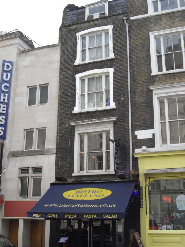
TQ 3080 NE CITY OF WESTMINSTER CATHERINE STREET, WC2
73/12
15.1.73 No. 15
G.V. II
Terraced house with shop. Mid C.19. Stock brick, slate roof. 4 storeys
and dormered mansard. 1 window wide. Altered late C.19 shop front to
ground floor. 1st floor window in stucco architrave with cornice, 2nd and
3rd floor windows segmental arched in stucco surrounds. Included for group
value only.
Listing NGR: TQ3056680933
External links are from the relevant listing authority and, where applicable, Wikidata. Wikidata IDs may be related buildings as well as this specific building. If you want to add or update a link, you will need to do so by editing the Wikidata entry.


Other nearby listed buildings
