Approximate Location Map
Large Map »
Latitude: 51.4154 / 51°24'55"N
Longitude: -1.5156 / 1°30'56"W
OS Eastings: 433782
OS Northings: 168603
OS Grid: SU337686
Mapcode National: GBR 706.7MS
Mapcode Global: VHC1S.PP38
Plus Code: 9C3WCF8M+5Q
Entry Name: 18, High Street
Listing Date: 8 June 1984
Grade: II
Source: Historic England
Source ID: 1210592
English Heritage Legacy ID: 395187
ID on this website: 101210592
Location: Hungerford, West Berkshire, RG17
County: West Berkshire
Civil Parish: Hungerford
Built-Up Area: Hungerford
Traditional County: Berkshire
Lieutenancy Area (Ceremonial County): Berkshire
Church of England Parish: Hungerford with Denford
Church of England Diocese: Oxford
Tagged with: Building
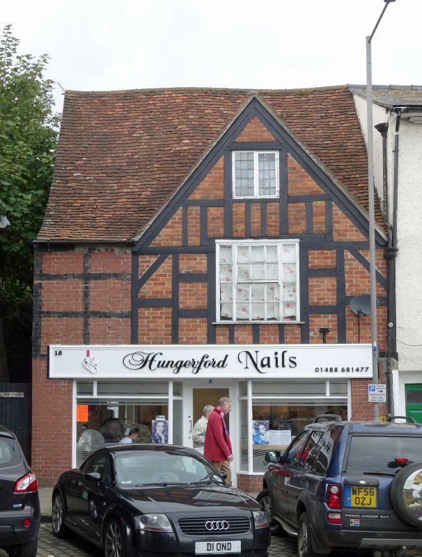
HUNGERFORD HIGH STREET (West side)
SU 3368
18/74 No.18
G.V. II
House, now offices. C17 with C20 alterations. Tiled roof with single
gable to road on left, brick wall with planted timbering. Timber framing
visible internally. 2 storeys and attic. One C20 casement in attic.
Tripartite glazing bar sash at first floor with exposed frame. C20 shop
front on ground floor.
Listing NGR: SU3378268603
External links are from the relevant listing authority and, where applicable, Wikidata. Wikidata IDs may be related buildings as well as this specific building. If you want to add or update a link, you will need to do so by editing the Wikidata entry.


Other nearby listed buildings
