Approximate Location Map
Large Map »
Latitude: 51.4158 / 51°24'56"N
Longitude: -1.5154 / 1°30'55"W
OS Eastings: 433798
OS Northings: 168640
OS Grid: SU337686
Mapcode National: GBR 706.1QY
Mapcode Global: VHC1S.PP71
Plus Code: 9C3WCF8M+8V
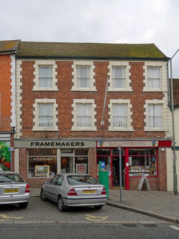
Entry Name: 13, High Street
Listing Date: 8 June 1984
Grade: II
Source: Historic England
Source ID: 1290399
English Heritage Legacy ID: 395177
ID on this website: 101290399
Location: Hungerford, West Berkshire, RG17
County: West Berkshire
Civil Parish: Hungerford
Built-Up Area: Hungerford
Traditional County: Berkshire
Lieutenancy Area (Ceremonial County): Berkshire
Church of England Parish: Hungerford with Denford
Church of England Diocese: Oxford
Tagged with: Building
HUNGERFORD HIGH STREET (West side)
SU 3368
18/37 No.13
G.V. II
House, now house and shop. C19. Tiled roof, eaves cornice, brick with
stucco chanelled quoins, dressings and keystones. 3 storeys. 4 sash
windows with marginal glazing. Modern shop fronts. Included for group
value.
Listing NGR: SU3379868640
External links are from the relevant listing authority and, where applicable, Wikidata. Wikidata IDs may be related buildings as well as this specific building. If you want to add or update a link, you will need to do so by editing the Wikidata entry.


Other nearby listed buildings
