Latitude: 52.6318 / 52°37'54"N
Longitude: 1.2985 / 1°17'54"E
OS Eastings: 623310
OS Northings: 308887
OS Grid: TG233088
Mapcode National: GBR W9S.FP
Mapcode Global: WHMTM.X3HR
Plus Code: 9F43J7JX+P9
Entry Name: The Louis Marchesi Public House
Listing Date: 26 February 1976
Last Amended: 8 April 1986
Grade: II*
Source: Historic England
Source ID: 1210774
English Heritage Legacy ID: 229672
Also known as: Louis Marchesi
Louis Marchesi, Norwich
ID on this website: 101210774
Location: The Close, Norwich, Norfolk, NR3
County: Norfolk
District: Norwich
Electoral Ward/Division: Thorpe Hamlet
Parish: Non Civil Parish
Built-Up Area: Norwich
Traditional County: Norfolk
Lieutenancy Area (Ceremonial County): Norfolk
Church of England Parish: Norwich St George, Tombland
Church of England Diocese: Norwich
Tagged with: Pub
TG 2308 NW TOMBLAND
(west side)
16/892
26.2.76. No. 17. The Louis
Marchesi P.H.
(formerly listed as
the Waggon & Horses P.H.).
GV II*
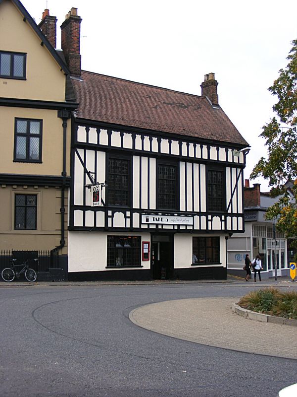
Former use unknown, now Public House. C15 undercroft. Late C15 street
range with C16 rear addition. C17. C18. alterations, adiitions. Rendered
masonry ground floor. Pseudo timber framing covering late C15 timber frame.
Plain tiles on street range and pantiles on rear range. Corner site, 'L'
shape plan. 2 storey. 3 bay street range with central door and C19 mullion
and transome windows with leaded lights. C19 timber-framing on first floor
with 9-light mullion and transome windows. The rear ground floor room has a
fine early C16 moulded timber ceiling which does not extend the full width
of the room, stopping short of the south wall to allow for a passage which
is lit by a frieze window. The first floor of the street range has the re-
mains of the C15 timber frame with expanded head wall posts, arch braces
and cambered ties. C19 roof, but the south gable has a truss embedded into
it, showing that the roof had diminished principal rafters, windbracing and
large cambered collars. Beneath the rear range is a 2 bay brick built under-
croft with heavy, double order diagonal ribs, 2 side and one end chamber.
The building is graded II for the undercroft, which forms part of an impor-
tant group within the City walls and for the surviving late C15 timber framing.
Listing NGR: TG2331008887
External links are from the relevant listing authority and, where applicable, Wikidata. Wikidata IDs may be related buildings as well as this specific building. If you want to add or update a link, you will need to do so by editing the Wikidata entry.


Other nearby listed buildings