Approximate Location Map
Large Map »
Latitude: 51.4976 / 51°29'51"N
Longitude: -0.6341 / 0°38'2"W
OS Eastings: 494910
OS Northings: 178508
OS Grid: SU949785
Mapcode National: GBR F8C.2HN
Mapcode Global: VHFT7.YMMB
Plus Code: 9C3XF9X8+28
Entry Name: Wheat Butts
Listing Date: 14 May 1973
Grade: II
Source: Historic England
Source ID: 1210949
English Heritage Legacy ID: 395513
ID on this website: 101210949
Location: Eton Wick, Windsor and Maidenhead, Berkshire, SL4
County: Windsor and Maidenhead
Civil Parish: Eton
Built-Up Area: Eton Wick
Traditional County: Buckinghamshire
Lieutenancy Area (Ceremonial County): Berkshire
Church of England Parish: Eton
Church of England Diocese: Oxford
Tagged with: Architectural structure
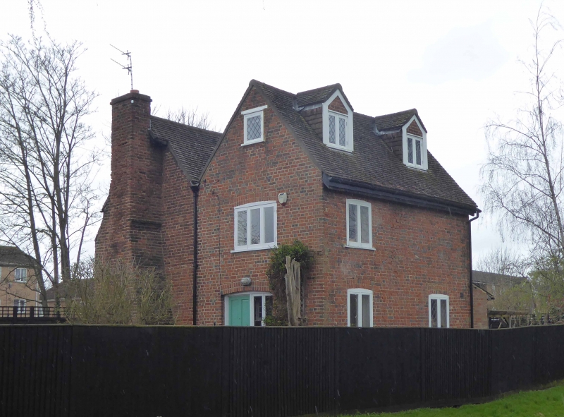
COMMON ROAD, ETON WICK
1.
1090 Wheat Butts
SU 97 NW 5/57
II
2.
C17 or earlier with C18 addition at back. Red brick, old tiled roof, 2 storeys,
3 casements flush set with lattice lights. Wide eaves, modern gabled porch. East
side chimney breast with offsets. Back wing with parallel roof, 2 storeys and
attics, 2 gabled dormers.
Listing NGR: SU9491078508
External links are from the relevant listing authority and, where applicable, Wikidata. Wikidata IDs may be related buildings as well as this specific building. If you want to add or update a link, you will need to do so by editing the Wikidata entry.


Other nearby listed buildings
