Approximate Location Map
Large Map »
Latitude: 50.3423 / 50°20'32"N
Longitude: -4.797 / 4°47'49"W
OS Eastings: 201079
OS Northings: 52889
OS Grid: SX010528
Mapcode National: GBR ZX.9H9M
Mapcode Global: FRA 08V4.70P
Plus Code: 9C2Q86R3+W6
Entry Name: 72 and 74, Bodmin Road
Listing Date: 11 March 1974
Grade: II
Source: Historic England
Source ID: 1211827
English Heritage Legacy ID: 396371
ID on this website: 101211827
Location: St Austell, Cornwall, PL25
County: Cornwall
Civil Parish: St Austell
Built-Up Area: St Austell
Traditional County: Cornwall
Lieutenancy Area (Ceremonial County): Cornwall
Church of England Parish: St Austell
Church of England Diocese: Truro
Tagged with: Building
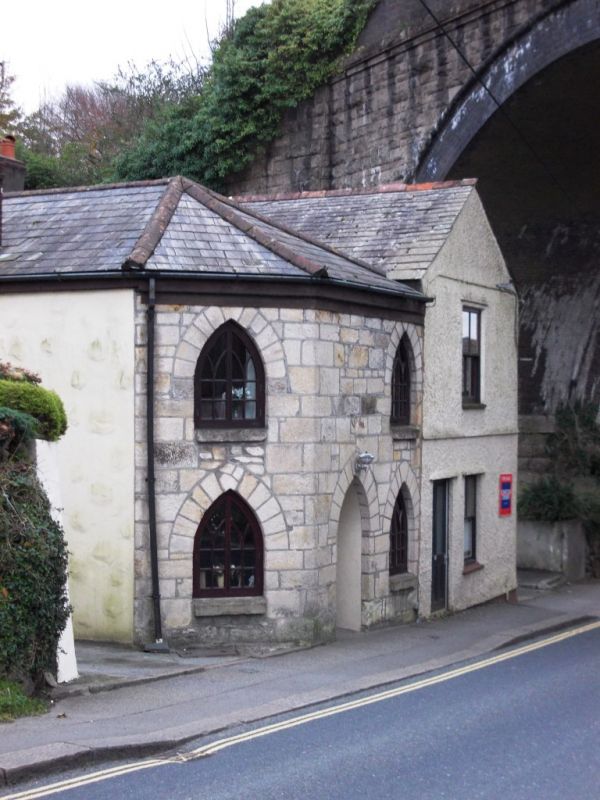
ST AUSTELL
1. BODMIN ROAD
1584A
Nos 72 & 74
SX 0152 1/469
II
2.
Early C19. Toll house. Colour-washed ashlar. 2 storeys. Splayed corner,
3 wtndows overall. "Gothick" casements with lancet heads and glazing
bars, two on 1st floor blocked. Central door with lancet head and panels.
Slate hipped roof. Adjoining is a later gabled addition, 2 storeys,
1 sash window, Victorian shop front.
Listing NGR: SX0107952889
External links are from the relevant listing authority and, where applicable, Wikidata. Wikidata IDs may be related buildings as well as this specific building. If you want to add or update a link, you will need to do so by editing the Wikidata entry.


Other nearby listed buildings
