Approximate Location Map
Large Map »
Latitude: 52.8054 / 52°48'19"N
Longitude: -2.1207 / 2°7'14"W
OS Eastings: 391962
OS Northings: 323101
OS Grid: SJ919231
Mapcode National: GBR 16X.4NC
Mapcode Global: WHBDT.DRD5
Plus Code: 9C4VRV4H+5P
Entry Name: Stafford College Tenterbanks Building
Listing Date: 16 February 1994
Grade: II
Source: Historic England
Source ID: 1212835
English Heritage Legacy ID: 384047
ID on this website: 101212835
Location: Broadeye, Stafford, Staffordshire, ST16
County: Staffordshire
District: Stafford
Electoral Ward/Division: Forebridge
Parish: Non Civil Parish
Built-Up Area: Stafford
Traditional County: Staffordshire
Lieutenancy Area (Ceremonial County): Staffordshire
Church of England Parish: Stafford St Mary
Church of England Diocese: Lichfield
Tagged with: Building
STAFFORD
SJ9123 TENTERBANKS STREET
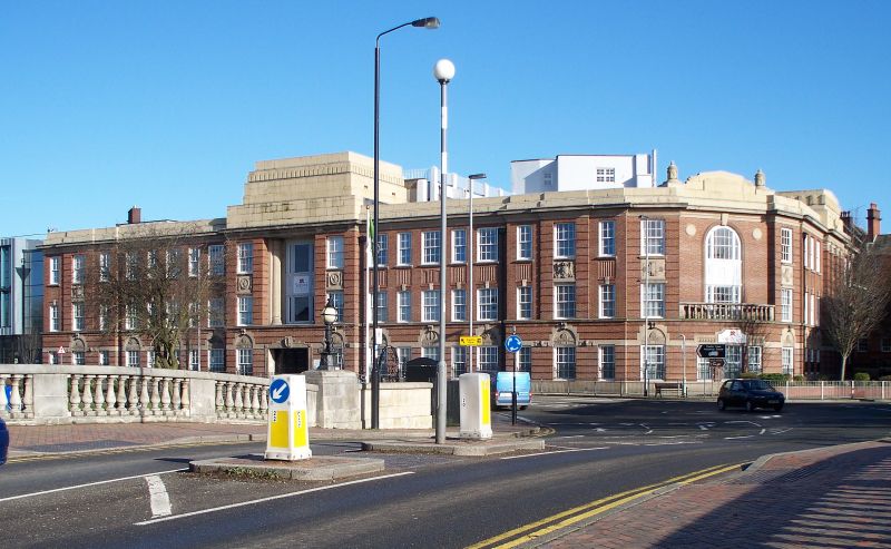
590-1/5/137 Stafford College: Tenterbanks
Buildings
II
College. c1937; interior completed 1946. Red-brown brick with
stone dressings and parapeted roof. Late classical style with
rusticated ground floor, rusticated pilaster panels at
intervals, moulded panel between floors and deep cornice and
blocking course.
EXTERIOR: 3 storeys, the centre breaking forward as a
frontespiece as do the ends of the main facade. 19-window
range of 10/10 and 8/8 sashes with curved stone heads to some
at intervals along the ground floor. Central doorway with
recessed section above having attached column either side.
Flat crowning feature above formed of low recessing sections.
To right a corner feature links to a similar facade to
Victoria Road Curved on ground floor with balustrade and flat
wall above having tall arched opening with tripartite windows
on both floors. Crowning feature with urns.
HISTORY: the shell of the building was completed in 1937,
after which it was used as an American army hospital during
the war, then completed afterwards.
Listing NGR: SJ9196223101
External links are from the relevant listing authority and, where applicable, Wikidata. Wikidata IDs may be related buildings as well as this specific building. If you want to add or update a link, you will need to do so by editing the Wikidata entry.


Other nearby listed buildings
